Detail View: Old Maps Collection: [East Indies, including a large "Java Maior" (Australia?) and coast of Asia]
|
Barcode:
|
4687820500914
|
|
Title:
|
[East Indies, including a large "Java Maior" (Australia?) and coast of Asia]
|
|
Contributor:
|
Oliva, Bartolomeo, 1538-1588, cartographer
|
|
Contributor:
|
Phillipps, Thomas, Sir, 1792-1872, former owner
|
|
Category:
|
Sea Charts
|
|
Type:
|
Manuscripts
|
|
Language:
|
Spanish
|
|
Create Year:
|
[1585]-[1599]
|
|
Format:
|
JPEG 2000, 6928 × 4992, 18.6MB
|
|
Page No.:
|
14
|
|
Scale:
|
Scale indeterminable.
|
|
Physical Map Dimension (cm):
|
45 x 32 cm, on sheet 51 x 37 cm
|
|
Note:
|
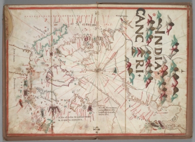
Bartolomeo Oliva was a cartographer that founded the family dynasty of Portolan cartographer from the island of Maiorca, Spain. The family first worked in Maiorca and later moved to Messina, Naples, and Marseille. They kept the Majorcan cartographic tradition going, while also introducing Italian and oriental influences. The Portolan in which this map is included was also most probably made in Maiorca as nomenclature is mainly in Spanish. This particular chart is of the East Indies from Bengala extending to what seems to be Korea, strangely correctly depicted as a Peninsula which was not common at the time being almost always an island. The coast lines of Sumatra and Malacca are fairly accurate but the Gulf of Tonkin is fairly exaggerated and China is not even identified, although the outlines of the Pearl River are already present. The Philippines are incomplete and Taiwan is missing. Java is enlarged and with the toponym 'Java Maior' with the Sonda Islands and Timor denominated as 'Java Menor' a common mistake on 16th century charts.
|
|
Note:
|
Original is a colored manuscript map in parchment from a Portolan Atlas, 22 x 33 cm.
|
|
Note:
|
Title from provenance library.
|
|
Note:
|
There are the principal directions and with symbols for the 4 winds marked at the edges of the chart. An arrow indicating north, a cross on the east point, and a P (Ponente) and O (Ostro) for West and South respectively after the Mariner's Windrose. Rhumb line for the principal winds in black, half-winds in green and quarter-winds in red.
|
|
Note:
|
Table of leagues vertical on the left side of the map.
|
|
Note:
|
Relief shown pictorially.
|
|
Note:
|
Landmasses outlined in green, yellow and magenta with small islands colored, green, grey, red and yellow.
|
|
Note:
|
Tropic of Cancer and Equator line in yellow.
|
|
Note:
|
Place names in red with names of the bigger landmasses in black.
|
|
Note:
|
Map outlined in red border.
|
|
Reference:
|
Harrisse, H., Découverte et évolution cartographique de Terre-Neuve et des pays circonvoisins 1497-1501-1769, p. 513
|
|
Reference:
|
De Ricci, S. with the assistance of W. H. Wilson. Census of Medieval and Renaissance Manuscripts in the United States and Canada, p. 42
|
|
Reference:
|
Wagner, H.R. The Portolan Atlases of American Interest in the Henry E. Huntington Library and Art Gallery in Essays offered to Herbert Putnam, p. 498-509
|
|
Reference:
|
Public Archives. Sixteenth-Century Maps Relating to Canada; a check-list and bibliography, p. 223, n. 827
|
|
Subject:
|
Asia -- Maps
|
|
Geographic Area:
|
East Indies
|
|
Geographic Area:
|
India
|
|
Geographic Area:
|
China
|
|
Geographic Area:
|
Sumatra (Indonesia)
|
|
Geographic Area:
|
Malacca (Malacca, Malaysia)
|
|
Geographic Area:
|
Vietnam
|
|
Geographic Area:
|
Cambodia
|
|
Geographic Area:
|
Borneo
|
|
Geographic Area:
|
Korea
|
|
Geographic Area:
|
Philippines
|
|
Geographic Area:
|
Java (Indonesia)
|
|
Geographic Area:
|
Hainan Sheng (China)
|
|
Geographic Area:
|
Thailand
|
|
Geographic Area:
|
Laos
|
|
Geographic Area:
|
Singapore
|
|
Geographic Area:
|
Sonda Islands
|
|
Geographic Area:
|
Timor Island
|
|
Relation Note:
|
[ff. 14]
|
|
Pub Title:
|
[Portolan atlas, Spanish]. [Majorca], [1585-1599].
|
|
Pub Author:
|
Oliva, Bartolomeo, 1538-1588
|
|
Pub Year:
|
[1585]-[1599]
|
|
Pub location:
|
[Majorca]
|
|
Provenance:
|
Huntington Library Collection
|
|
Provenance:
|
https://catalog.huntington.org/record=b1862006
|
|
Provenance Call No.:
|
mssHM 32
|
|
MUST holding:
|
https://must.primo.exlibrisgroup.com/permalink/853MUST_INST/171sgkf/alma991002993749805076
|