Detail View: Old Maps Collection: [Southeast China, Japan, East Indies (northern part)]
|
Barcode:
|
3687800354088H
|
|
Title:
|
[Southeast China, Japan, East Indies (northern part)]
|
|
Other Title:
|
Mapa Mumdo
|
|
Other Title:
|
Mapa Mvmdo
|
|
Contributor:
|
Dourado, Fernão Vaz, 1520-1580, cartographer
|
|
Contributor:
|
Huth, Henry, 1815–1878, former owner
|
|
Category:
|
Sea Charts
|
|
Type:
|
Manuscripts
|
|
Language:
|
Portuguese
|
|
Language:
|
Latin
|
|
Create Year:
|
[1570]
|
|
Format:
|
JPEG 2000, 7072 × 5776, 41.4MB
|
|
Page No.:
|
12
|
|
Scale:
|
Scale not given.
|
|
Physical Map Dimension (cm):
|
32 x 42 cm, on sheet 38 x 52 cm
|
|
Note:
|
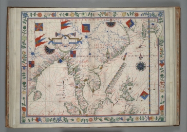
Fernão Vaz Dourado has always been considered a great cartographer and has been called by some authors the most famous and remarkable 16th century Portuguese cartographer. His works will always be outstanding for the artistic beauty of its illumination. The Atlas in which this map is inserted was probably made in 1570 in Goa where the cartographer lived until 1571. It is from a series of other several similar Atlases, being the earliest one from 1568. This Atlas is not signed or dated but had a frontispiece that disappeared and it is not known what was written in it. According to H. Huth the manuscript came from the Library of the Archbishop of Toledo but A. Cortesão clarifies the Atlas was in the Biblioteca Nacional in Madrid until 1866 but disappeared after being taken to the Paris Exhibition in 1867. In 1874 was sold by Quaritch -a London antiquary bookseller- to the English collector Henry Huth. This map includes a key early depiction of Japan as well as the first mention of Macao on a map. On the west side of Pearl River are marked 'Camtäo' and 'Camäo' which refers to Guangzhou and Jiangmen respectively.
|
|
Note:
|
The original is a manuscript Portolan Atlas of 40 fl. on parchment, 27 x 41 cm. Bifolia attached sequentially with stubs, each map has wide borders decorated with floral designs and legends. On the front pastedown has the ex libris of Henry Huth, a former owner of the manuscript. Bound, ca. 1680, in French brown morocco, gilt spine with lettering MAPA MVMDO [sic]. This map is f. 12.
|
|
Note:
|
Title from the provenance library.
|
|
Note:
|
The map has two coats of arms with stylizations of Arabic nations; and six banners, three of Portugal, two of Arabic nations and one of the Order of Christ. There is a one full, 1/2 and a 5/8, 32-point compass roses in black, blue, red, green and gold; two of them with a fleur-de-lis indicating north. As for the rhumb lines, the principal winds are in black, the half-winds in green and the quarter-winds in red.
|
|
Note:
|
Scale line in ornamented cartouche.
|
|
Note:
|
Latitude line at the right side in gold and blue interchangeably. Line of Tropic of Cancer in red.
|
|
Note:
|
Area names in square capitals with toponyms in black and red ink in minuscule script. Land masses outlined in green with small islands painted gold, red and blue.
|
|
Note:
|
Flowery bordure with butterflies, snails and birds.
|
|
Note:
|
Macao in East Indies maps.
|
|
Note:
|
In Latin and Portuguese.
|
|
Reference:
|
Cortesão, A. Portugalliae Monumenta Cartographica, vol. 3, p. 3-8, 13-16
|
|
Reference:
|
Cortesão, A. Cartografia e cartógrafos portugueses dos séculos XV e XVI, vol. 2, p. 59-64
|
|
Reference:
|
Guide to medieval and Renaissance manuscripts in the Huntington Library, vol. 1, p. 99-100
|
|
Reference:
|
Ricci, S. de Census of Medieval and Renaissance Manuscripts in the United States and Canada, p. 43-44
|
|
Reference:
|
Wagner, H.R. The Cartography of the Northwest Coast of America to the Year 1800, vol. 1, p. 62; vol. 2, p. 284
|
|
Reference:
|
Wagner, H.R. The Portolan Atlases of American Interest in the Henry E. Huntington Library and Art Gallery, in Essays offered to Herbert Putnam, p. 498-509
|
|
Reference:
|
Canada. Public Archives. Sixteenth-Century Maps Relating to Canada: a check-list and bibliography, p. 151
|
|
Subject:
|
Atlas
|
|
Geographic Area:
|
East Indies
|
|
Geographic Area:
|
China
|
|
Geographic Area:
|
Korea
|
|
Geographic Area:
|
Japan
|
|
Geographic Area:
|
India
|
|
Geographic Area:
|
Ceylon
|
|
Geographic Area:
|
Malaysia
|
|
Geographic Area:
|
Thailand
|
|
Geographic Area:
|
Cambodia
|
|
Geographic Area:
|
Vietnam
|
|
Geographic Area:
|
Paracel Islands
|
|
Geographic Area:
|
Philippines
|
|
Geographic Area:
|
Borneo
|
|
Relation Note:
|
[f. 12]
|
|
Pub Title:
|
[Portolan atlas], [Goa], 1570.
|
|
Pub Author:
|
Dourado, Fernão Vaz, 1520-1580
|
|
Pub Year:
|
1570
|
|
Pub location:
|
[Goa]
|
|
Provenance:
|
Huntington Library Collection
|
|
Provenance:
|
https://catalog.huntington.org/record=b1862015
|
|
Provenance Call No.:
|
mssHM 41
|
|
MUST holding:
|
https://must.primo.exlibrisgroup.com/permalink/853MUST_INST/171sgkf/alma991002923848405076
|