Detail View: Old Maps Collection: Planta topográfica da cidade de Macau
|
Barcode:
|
36878003546018
|
|
Title:
|
Planta topográfica da cidade de Macau
|
|
Original Title:
|
Planta topographica da cidade de Macáo
|
|
Contributor:
|
Osório, Cândido António, 1803-1874, cartographer
|
|
Contributor:
|
Guimarães, João, creator
|
|
Category:
|
Topographic Maps
|
|
Type:
|
Printed
|
|
Language:
|
Portuguese
|
|
Create Year:
|
1989
|
|
Create Year:
|
1838
|
|
Format:
|
JPEG 2000, 6217 × 4541, 22.1MB
|
|
Scale:
|
Scale not given.
|
|
Physical Map Dimension (cm):
|
80 x 111 cm
|
|
Note:
|
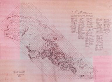
António Cândido Osório was a Macanese born in the civil parish of Sé in 1803. He joined the Navy and by 1842 was an officer of the corvette “Infanta Regente” and in 1844 the commander of the brig “Simplícia”, which wrecked on October 9th, 1844 on a rock south of Hutou Shan. The plan is mentioned on the “Ta-Ssi-Yang-Kuo” in an article by João Feliciano Marques Pereira (1863-1909), another Macanese, who in 1899 started the 2nd series of the magazine “Ta-Ssi-Yang-Kuo”, established by his father, António Feliciano Marques Pereira (1839-1881), in 1863. He bought the plan in Lisbon mentioning it is large scaled, a manuscript and unpublished. He admits to have bought it because of a pinpointed place name, “Boca do Inferno” (lit. Hellmouth), letter “L” on the map. This was a place near Praia de Cacilhas, that no longer exists due to land reclamation, which seems to be where the Dutch disembarked on June 24th of 1622, the day of the infamous Battle of Macao, where the Portuguese fought the Dutch for settlement in Macao. The author divided the locations given in the legend in Chinese dwellings –inside and outside the city– and civil parishes of Santo António, Sé and São Lourenço. A total of 175 place names are located and identified in the legend. Although it appears as a mere sketch, it is a very detailed one, particularly with the position and location of buildings. In fact, this plan is the most accurate city plan of Macao of its time.
|
|
Note:
|
This is a copy made in November 29th, 1989 at the Gabinete de Estudos Arqueológicos da Engenharia Militar by the designer of the Serviços de Fortificações e Obras do Exército, Região Militar de Lisboa, soldier João Guimarães. From an original manuscript map, 109 x 99 cm.
|
|
Note:
|
Relief shown pictorially and by hachures.
|
|
Note:
|
Oriented with east at the top.
|
|
Note:
|
Map with grid.
|
|
Note:
|
City plans of Macao.
|
|
Reference:
|
Marques Pereira, J.F. Hollandezes contra Macau, Ta-Ssi-Yang-Kuo, série I, vol. I-II, pp. [79]-103
|
|
Subject:
|
Macao (China) -- Maps
|
|
Geographic Area:
|
Macao (China)
|
|
Provenance:
|
Exército Português - DIE/GEAEM
|
|
Provenance:
|
https://bit.ly/3qdcRiA
|
|
Provenance Call No.:
|
1243/C-2A-28A-rolo pr„prio
|
|
MUST holding:
|
https://must.primo.exlibrisgroup.com/permalink/853MUST_INST/171sgkf/alma991003022249705076
|