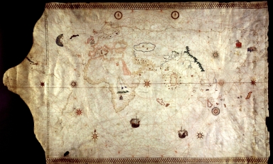
Detail View: Old Maps Collection: [Portolan chart]

|
Barcode:
|
3687800354085E
|
|
Title:
|
[Portolan chart]
|
|
Other Title:
|
King-Hamy Portolan chart
|
|
Category:
|
Sea Charts
|
|
Type:
|
Manuscripts
|
|
Language:
|
Latin
|
|
Create Year:
|
[ca. 1502]
|
|
Format:
|
JPEG 2000, 22.7 MB
|
|
Scale:
|
Scale not given.
|
|
Physical Map Dimension (cm):
|
29 x 47 cm, on sheet 42 x 56 cm
|
|
Note:
|
This nautical chart was possibly made in Italy after a Portuguese prototype early in the 16th century. Some authors seem to attribute this chart to Amerigo Vespucci. It belonged to arctic traveler Richard King, then was bought in London by Alphonse Pinart. In Paris in 1885 was bought by Dr. Jules Théodore Ernest Hamy and subsequently by James William Ellsworth. The library of the latter was purchased by A.S.W. Rosenbach who sold this chart to Henry E. Huntington in 1923. It's one of the earliest maps to have a representation of the New World; America is represented by Greenland, Newfoundland and Labrador, the Antilles, the north coast of South America and the East coast of Brazil. This chart is also the first to give the name 'Insulae solis' to archipelago Azores, Portugal.
|
|
Note:
|
Original map is manuscript on parchment, 59 x 94 cm.
|
|
Note:
|
Title from provenance library.
|
|
Note:
|
The map has 12 compass roses, three of them with an arrow indicating north. As for the rhumb lines the principal and half winds are in green, the quarter winds in red.
|
|
Note:
|
Decorated with two vessels and a few figures and vignettes very faded.
|
|
Note:
|
Land masses outlined in yellow with islands painted blue, red, gold or silver.
|
|
Note:
|
Latitude lines on both sides of the map. Equator line in red.
|
|
Note:
|
Relief is show pictorially.
|
|
Note:
|
Toponyms in minuscule black and red ink with area names in square capitals.
|
|
Note:
|
Top and bottom border decorated with gold in trellis pattern.
|
|
Reference:
|
Magnaghi, A. Il planisfero del 1523 della Biblioteca del Re in Torino, p. 27
|
|
Reference:
|
Caraci, G. Tabulae geographicae vetustiores in Italia adservatae, vol. 3, p. 62
|
|
Reference:
|
Randles, W.G.L. From the Mediterranean Portulan Chart to the Marine World Chart of the Great Discoveries: The Crisis in Cartography in the Sixteenth Century, Imago Mundi, vol. 40, p. 115-118
|
|
Reference:
|
Duzer, C. van Cartographic Invention: The Southern Continent on Vatican MS Urb. Lat. 274, Folios 73v-74r (c.1530), Imago Mundi, vol. 59, no. 2, p. 195
|
|
Reference:
|
McIntosh, G.C. The Piri Reis Map of 1513
|
|
Reference:
|
Hamy, E.T. Notice sur une mappemonde Portugaise anonyme de 1502, récemment découverte à Londres
|
|
Subject:
|
Nautical Chart
|
|
Geographic Area:
|
World
|
|
Geographic Area:
|
South America
|
|
Geographic Area:
|
Europe
|
|
Geographic Area:
|
Africa
|
|
Geographic Area:
|
Asia
|
|
Provenance:
|
Huntington Library Collection
|
|
Provenance:
|
https://catalog.huntington.org/record=b1842787
|
|
Provenance Call No.:
|
mssHM 45
|
|
MUST holding:
|
https://must.primo.exlibrisgroup.com/permalink/853MUST_INST/171sgkf/alma991002923848605076
|