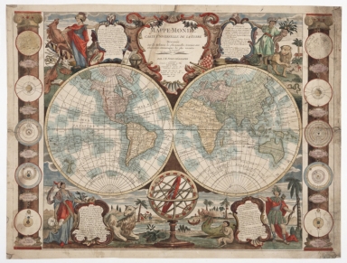
Detail View: Old Maps Collection: Mappe-monde : carte universelle de la terre, dressée sur les relations les plus nouvelles, soumises aux observations astronomiques les plus recentes ou sont marquées les nouvelles découvertes
|
Barcode:
|
36878003222424
|
|
Title:
|
Mappe-monde : carte universelle de la terre, dressée sur les relations les plus nouvelles, soumises aux observations astronomiques les plus recentes ou sont marquées les nouvelles découvertes
|
|
Other Title:
|
Disque du Soleil.
|
|
Other Title:
|
L'Hemisphere de la Terre eclairée p[ar] le Soleil au solstice d 'Ete.
|
|
Other Title:
|
Sisteme de Copernic.
|
|
Other Title:
|
Sisteme de Tico-brahe.
|
|
Other Title:
|
Eclipse de Soleil.
|
|
Other Title:
|
Disque de la Lune.
|
|
Other Title:
|
L'Hemisphere de la Terre eclairée par le Soleil au solstice d 'Hyver.
|
|
Other Title:
|
Sisteme Ptolomée.
|
|
Other Title:
|
Sisteme de Descartes.
|
|
Other Title:
|
Eclipse de Lune.
|
|
Contributor:
|
Nolin, Jean Baptiste, 1686-1762, cartographer
|
|
Contributor:
|
Denis, Louis, 1725-1794, editor
|
|
Contributor:
|
Basset, Paul-André, 1759-1829, printer
|
|
Category:
|
General Maps
|
|
Type:
|
Manuscripts
|
|
Language:
|
French
|
|
Create Year:
|
[ca. 1779]
|
|
Format:
|
JPEG 2000, 31.4 MB
|
|
Scale:
|
Scale not given.
|
|
Physical Map Dimension (cm):
|
48 x 65 cm
|
|
Note:
|
Double hemisphere map with 10 ancillary astronomical maps, five on each side of the central hemispheres, each with a legend. The map depicts partial coastlines for Australia, Tasmania, and New Guinea. On the map are marked the sailing routes of Captain James Cook and other voyages. This is an early edition of this map that later was issued after the final voyage of said Captain with respective amends.
|
|
Note:
|
Double hemisphere map with 10 ancillary astronomical maps: Disque du Soleil. - 5 cm. -- L'Hemisphere de la Terre eclairée p[ar] le Soleil au solstice d 'Ete. - 5 cm. -- Sisteme de Copernic. - 5 cm. -- Sisteme de Tico-brahe. - 5 cm. -- Eclipse de Soleil. - 5 cm. -- Disque de la Lune. - 5 cm. -- L'Hemisphere de la Terre eclairée par le Soleil au solstice d 'Hyver. - 5 cm. -- Sisteme Ptolomée. - 5 cm. -- Sisteme de Descartes. - 5 cm. -- Eclipse de Lune. - 5 cm.
|
|
Note:
|
The double hemisphere is surrounded by representations of the four continents: Europe represented in the form of Athena accompanied by a horse and surrounded by representations of the arts, painting, sculpture, music, astronomy, etc.; Africa represented by a native with an elephant hat and a cornucopia is his left hand, lion at his side; Asia represented by an Arabic with an incense burner on his right hand and close to him a camel, finally America in the form of an Indian dressed in feathers and a bow in hand, a crocodile at his side with other representations of natives. Each one of the representations has at its side a scrollwork cartouche with legends about said continents. At the center bottom there is an armillary sphere.
Title inside scrollwork cartouche at the center on the top part of the map.
|
|
Note:
|
Equator line in black and white interchangeably.
|
|
Note:
|
Continents in different colours.
|
|
Note:
|
Relief shown pictorially.
|
|
Note:
|
Map outlined in simple fillet.
|
|
Note:
|
Macao in World maps.
|
|
Subject:
|
Wall map
|
|
Geographic Area:
|
World
|
|
Geographic Area:
|
North America
|
|
Geographic Area:
|
Central America
|
|
Geographic Area:
|
South America
|
|
Geographic Area:
|
Asia
|
|
Geographic Area:
|
Oceania
|
|
Geographic Area:
|
Africa
|
|
Geographic Area:
|
Europe
|
|
Provenance:
|
Huntington Library Collection
|
|
Provenance:
|
https://catalog.huntington.org/record=b1339861
|
|
Provenance Call No.:
|
281742
|
|
MUST holding:
|
https://must.primo.exlibrisgroup.com/permalink/853MUST_INST/reglfj/alma991000818389705076
|