Detail View: Old Maps Collection: Carta da Europa e do Mediterraneo
|
Barcode:
|
4687820500829
|
|
Title:
|
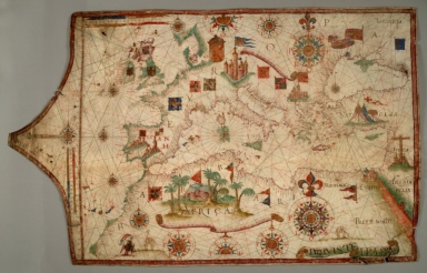
Carta da Europa e do Mediterraneo
|
|
Original Title:
|
Nautical chart of Mediterranean area, including Europe with the British Isles and part of Scandinavia.
|
|
Contributor:
|
Teixeira, Luís, active 16th century
|
|
Category:
|
Sea Charts
|
|
Type:
|
Manuscripts
|
|
Language:
|
Latin
|
|
Create Year:
|
16th
|
|
Format:
|
JPEG2000, 44 MB
|
|
Scale:
|
Scale not given
|
|
Physical Map Dimension (cm):
|
950 x 595 mm
|
|
Note:
|
Nautical chart of Mediterranean area, including Europe with the British Isles and part of Scandinavia.
|
|
Note:
|
TN 59080
|
|
Geographic Area:
|
Europe
|
|
Geographic Area:
|
Mediterranean Sea
|
|
Geographic Area:
|
British Isles
|
|
Pub location:
|
Portugal
|
|
Provenance:
|
Huntington Library Collection
|