Detail View: Old Maps Collection: [World chart]
|
Barcode:
|
3687800354089I
|
|
Title:
|
[World chart]
|
|
Contributor:
|
Brouscon, Guillaume, fl. 15--, cartographer
|
|
Contributor:
|
Cossé, Artus de, 1512-1582, former owner
|
|
Category:
|
Sea Charts
|
|
Type:
|
Manuscripts
|
|
Language:
|
French
|
|
Create Year:
|
1543
|
|
Format:
|
JPEG 2000, 57.6 MB
|
|
Page No.:
|
1
|
|
Scale:
|
Scale not given.
|
|
Physical Map Dimension (cm):
|
47 x 55 cm, on sheet 57 x 64 cm
|
|
Note:
|
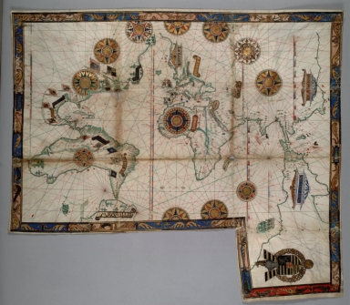
This chart is part of a series of world maps called 'Dieppe maps'. These were produced in Dieppe, France, in the 1540s, 1550s, and 1560s. They are large handmade maps, commissioned for wealthy and royal patrons. This particular map is included in a manuscript containing a Portolan chart and a Nautical almanac. Although the author Harrisse in his 'Découverte fortuite de l'Australie' -among others- have assigned the work to Giovanni Benedetto, it is now attributed to Guillaume Brouscon because of the Breton saints in the calendar, the Breton port nomenclature, and the marked similarities to other Brouscon manuscripts. On the chart America is already included although the Western and Northern borders of North America are not complete. South America is greatly enlarged with an outline that resembles Australia. At the right there is 'Terre Ostrale' connected to Java that, in the author's view, could be a continent of sorts extending to the pole. Like most nautical charts the map in richer on coast place names but has very few or none in territorial interiors. The coat of arms on the bottom was originally bound into the front of the volume.
|
|
Note:
|
Original is a manuscript map in parchment by Guillaume Brouscon, 46 x 68 cm.
|
|
Note:
|
Title from provenance library.
|
|
Note:
|
In Europe it can be seen coats of arms of the different kingdoms and in America there are flags of Portugal, Spain and even France. Jerusalem is depicted as a calvary and the Red Sea is painted red. On the bottom side oriented East there is the coat of arms of Artus de Cossé, Maréchal de France (1512-1582), most probably the first owner of the work.
|
|
Note:
|
There are twelve 32-point compass roses on the map: seven being full, two half compass roses and three 3/4 compass rose. All of them are decorated in black, red, blue and gold, and others have green as well. As for the rhumb lines the principal winds are in black, the half-winds in green and the quarter-winds in red.
|
|
Note:
|
Scale line in gold with a fleur-de-lis on each side.
|
|
Note:
|
Relief shown pictorially.
|
|
Note:
|
There are six latitude lines in red and blue interchangeably.
|
|
Note:
|
Land masses outlined in green and islands colored red, blue, green and gold.
|
|
Note:
|
Continent names either in banderoles or cartouches. Place names in black and red.
|
|
Note:
|
Map in colored border with acanthus leaves and figures with the initials 'GB' and the year '1543'.
|
|
Reference:
|
Rust, V. Guide to Medieval and Renaissance Manuscripts in the Huntington Library, vol. 1, p. 104
|
|
Reference:
|
Anthiaume, A. Cartes marines, constructions navales, voyages de découverte chez les normands, 1500-1650, vol. 2, p. 493-496
|
|
Reference:
|
Sympson, M. New World Propaganda: Pigafetta's Journal, World Maps, and New European Ideologies, 1525-1556, HIST4800 Early America in the Atlantic World, Paper 3, p. 4
|
|
Reference:
|
Hervé, R. Découverte fortuite de l'Australie et de la Nouvelle-Zélande par des navigateurs portugais et espagnols entre 1521 et 1528, p. 81-87
|
|
Reference:
|
Waters, D.W. The Art of Navigation, p. 32-33, 505
|
|
Reference:
|
Thompson, H.Y. Illustrations from One Hundred Manuscripts in the Library of Henry Yates Thompson, p. 21-22
|
|
Reference:
|
Harrisse, H., Découverte et évolution cartographique de Terre-Neuve et des pays circonvoisins 1497-1501-1769, p. 223-224
|
|
Reference:
|
De Ricci, S. Census of Medieval and Renaissance Manuscripts in the United States and Canada, p. 45
|
|
Reference:
|
Worth, H. An alternative view of Jave la Grande: approaches to cartographic history and their impact on the interpretations of the Dieppe maps, vol. 33, no. 1 (2011), p. 28-49
|
|
Reference:
|
Wagner, H.R. The Portolan Atlases of American Interest in the Henry E. Huntington Library and Art Gallery, Essays offered to Herbert Putnam, p. 498-509
|
|
Reference:
|
Wallis, H. The Maps and Text of the Boke of Idrography Presented by Jean Rotz to Henry VIII now in the British Library, p. 39
|
|
Reference:
|
Dujardin-Troadec, L. Les Cartographes Bretons Du Conquet
|
|
Subject:
|
Dieppe Maps
|
|
Geographic Area:
|
World
|
|
Geographic Area:
|
North America
|
|
Geographic Area:
|
Central America
|
|
Geographic Area:
|
South America
|
|
Geographic Area:
|
Europe
|
|
Geographic Area:
|
Africa
|
|
Geographic Area:
|
Africa
|
|
Geographic Area:
|
Oceania
|
|
Relation Note:
|
[Part 1. f. 1.]
|
|
Pub Title:
|
[Portolan chart]
|
|
Pub Author:
|
Brouscon, Guillaume, fl. 15--
|
|
Pub Year:
|
[1540-1560]
|
|
Pub location:
|
[Le Conquet]
|
|
Provenance:
|
Huntington Library Collection
|
|
Provenance:
|
https://catalog.huntington.org/record=b1862019
|
|
Provenance Call No.:
|
mssHM 46
|
|
MUST holding:
|
https://must.primo.exlibrisgroup.com/permalink/853MUST_INST/reglfj/alma991002923849605076
|