Detail View: Old Maps Collection: Vesconte Maggiolo, Portolan Chart
|
Barcode:
|
4687820500827
|
|
Title:
|
Vesconte Maggiolo, Portolan Chart
|
|
Original Title:
|
Vesconte de Maiollo inuense composuit hanc cartam in napoli anno 1516 die 7 maio
|
|
Contributor:
|
Maggiolo, Vesconte, active 1504-1549
|
|
Category:
|
Sea Charts
|
|
Type:
|
Manuscripts
|
|
Language:
|
Italian
|
|
Create Year:
|
1516
|
|
Format:
|
JPEG2000, 23.3 MB
|
|
Scale:
|
Scale not given
|
|
Physical Map Dimension (cm):
|
1020 × 1520
|
|
Note:
|
TN 66795
|
|
Note:
|
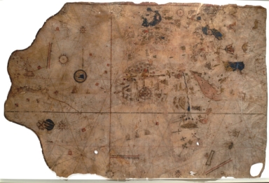
Black and red ink for nomenclature in a minuscule hand with area names in gothic script; American coast, Scotland, and England outlined in color (very faded), other land masses in black ink only; 10 compass roses with usual 32 rhumb line network in black, red and green ink for the principal directions; latitude scale numbered from 40° S to 67° N, no longitude; 4 unnumbered scales of distance; decorated with imaginary animals, kings in pavillions, vignettes of cities, banners, 3 wind-heads, and a large medallion of the Virgin and Child. Provided in Digital Scriptorium of Huntington Library.
|
|
Subject:
|
Virgin and Child
|
|
Subject:
|
Religious
|
|
Geographic Area:
|
England
|
|
Geographic Area:
|
Europe
|
|
Geographic Area:
|
Africa
|
|
Geographic Area:
|
North America
|
|
Geographic Area:
|
South America
|
|
Geographic Area:
|
Middle East
|
|
Pub Year:
|
1516
|
|
Provenance:
|
Huntington Library Collection
|