Detail View: Old Maps Collection: Consult the numbers in the city of Macau
|
Barcode:
|
3687800354234A
|
|
Title:
|
Consult the numbers in the city of Macau
|
|
Original Title:
|
Aen wijsmge met cijferletters, in de stadt van Macao
|
|
Other Title:
|
Bird's eye view of Macao
|
|
Other Title:
|
Stadtplan von Macao
|
|
Contributor:
|
Vinckeboons, Joan, 1617-1670, cartographer
|
|
Category:
|
City Plans & Views
|
|
Type:
|
Printed
|
|
Language:
|
Dutch
|
|
Create Year:
|
[1668]
|
|
Format:
|
JPEG 15831 x 6550, 54MB
|
|
Page No.:
|
19
|
|
Scale:
|
Scale not given.
|
|
Physical Map Dimension (cm):
|
53 x 130 cm, on sheet 56 x 134 cm
|
|
Note:
|
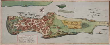
The original is a Atlas factice consisting of Joan Blaeu's 'Atlas Maior' and Van Der Hem's additions. Between 1662-1672 Joan Blaeu published his famous 'Atlas Maior' edited in Latin, French, Dutch, and Spanish, and, bound in nine to twelve volumes, depending on the edition. For over a hundred years, Blaeu's 'Atlas Maior' -with almost 600 maps and 3000 pages of text- remained the standard world atlas. Laurens van der Hem, an Amsterdam lawyer, had begun collecting maps and topographical drawings as early as 1645 and when the Latin edition of Blaeu's 'Atlas Maior' was published in 1662, he acquired a copy -in 11 volumes- which he used to make an even more ambitious collection of maps, topographical drawings and prints. Van der Hem arranged the sheets in the Atlas according to his own ideas, amplifying the volumes with more than 1800 maps, charts, townscapes, architectural prints, portraits, etc. Besides prints, the atlas also contains a wealth of drawings: maps, townscapes, seascapes, renderings of foreign people, among others always in the size of sheets from 'Atlas Maior' to maintain the harmony of the work -if too wide, they were folded in; if too small, they were enlarged, and coloured in such a way that the transition from original print to enlargement became invisible; if too high, they were reduced in format, or cut into pieces, and separately pasted on blank leaves. Among the most impressive of Van der Hem's additions are the set of four volumes of manuscript-maps and drawings, which were originally made for the East Indies Company -in which this map is included. The complete work resulted in a 50-volume atlas. When Van der Hem died his children inherited the atlas, his daughter Agatha kept the Atlas for many years. After Agatha's death the atlas was auctioned by Adriaan Moetjens in The Hague in 1730, the buyer was Prince Eugene of Savoie (1663-1736), stadtholder-general of the Austrian Netherlands and a known art-lover and collector. After Eugene's death in 1736 his widow sold the Atlas to Charles VI, Holy Roman Emperor, who kept it in his Hofbibliothek, which is nowadays the Austrian National Library. In 2009 the HES & De Graaf Publishers made an 8 volume facsimile comprising volumes 35-45 of the original, limited edition of 100 sets. Although Joan Vinckeboons has never been to Asia himself he made quite a few city elevations, plans, coastal profiles and sea charts with combined information based on reports and sketches that masters, helmsmen and merchants made on their travels under the orders of the Dutch East India Company and Dutch West India Company. In this striking watercolor, just as on the others of Macao by Vinckeboons, the aerial perspective is maintained. Compared to the other view this particular one is elongated on the north to be able to show the Border Gate. This view is drawn in a way that enables the map to be "read" from both the perspective of the Inner Harbor as well as the one from the Bay of the Praia Grande. On the legend there are marked 26 places, the forts, churches and temples. The military interest of said legends is undeniable, for instance n.o 1 'Is Het Princepael fort St. Paulo, Leijdt hoogh 185 trappen, met 18 stucken geschut' states the exact location of the main São Paulo Fort and the number of artillery pieces present; n.o 8 'S.ta [sic] Francisco, waer op Sijn 10 Stucken' states the São Francisco Fort with it's 10 artillery pieces and n.o 16 'De Baare heest 15 Stucken' the Barra Fort with 15.
|
|
Note:
|
Original is a manuscript watercolored view by Johannes Vingboons from 'The Secret Atlas of the East India Company' in the 'Atlas Blaeu-Van der Hem', 53 x 133 cm.
|
|
Note:
|
There is a 16-point compass rose with a fleur-de-lis indicating north and a cross on East point. It is colored red, blue and gold.
|
|
Note:
|
Map outlined in red and yellow border.
|
|
Note:
|
City plans of Macao.
|
|
Reference:
|
Ausserer, K. Der Atlas Blaeu der Wiener National-Bibliothek, Beiträge zur historiche Geographie, p. 1-40
|
|
Reference:
|
Groot, E. de The Atlas Blaeu-Van der Hem of the Austrian National Library
Horst, K. van der The Atlas Blaeu-Van Der Hem : history of the Atlas and the making of the facsimile
|
|
Reference:
|
Explokart Research Project, https://www.explokart.eu/research/vanderhem.html
|
|
Geographic Area:
|
Macao (China)
|
|
Relation Note:
|
Bd. 41:19, fol. 83-84, (19)
|
|
Pub Title:
|
Atlas Blaeu-Van der Hem : a facsimile-edition of the unique copy preserved in the Austrian National Library, Vienna.
|
|
Pub Year:
|
2009
|
|
Pub location:
|
't Goy-Houten
|
|
Provenance:
|
Austrian National Library
|
|
Provenance:
|
http://data.onb.ac.at/rec/baa12661678
|
|
Provenance Call No.:
|
389030-F.K. KAR MAG
|
|
MUST holding:
|
https://must-primo.exlibris.com.cn/permalink/853MUST_INST/171sgkf/alma991002969649805076
|