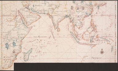
Detail View: Old Maps Collection: Map of the Indian Ocean
|
Barcode:
|
4687820500094
|
|
Title:
|
Map of the Indian Ocean
|
|
Original Title:
|
Landkarte von Niederländisch-Ostindien vom Kap der Guten Hoffnung bis Japan
|
|
Contributor:
|
Vinckeboons, Joan
|
|
Category:
|
Sea Charts
|
|
Type:
|
Printed
|
|
Language:
|
Dutch
|
|
Create Year:
|
1668
|
|
Format:
|
JPEG, 8273 x 5000, 17.8MB
|
|
Scale:
|
Scale not given
|
|
Note:
|
This map provides an overview of the regions where the Dutch East India Company was active.
|
|
Note:
|
Macao in China Maps
|
|
Note:
|
Macao in East Indies Maps
|
|
Subject:
|
Nautical charts
|
|
Geographic Area:
|
Southeast Asia
|
|
Geographic Area:
|
Indian Ocean
|
|
Relation Note:
|
In: Atlas Blaeu - Van der Hem, Bd. 39:02, fol. 28 - 29, (1)
|
|
Pub Title:
|
The Atlas Blaeu-Van der Hem : a facsimile-edition of the unique copy preserved in the Austrian National Library, Vienna.
|
|
Pub Author:
|
Blaeu, Joan, 1596-1673
|
|
Pub Year:
|
2009
|
|
Pub location:
|
't Goy-Houten
|
|
Provenance:
|
|