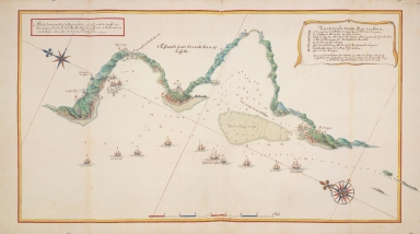
Detail View: Old Maps Collection: Map of the bay of Goa showing the blockade of Goa 1657-1658
|
Barcode:
|
4687820500093
|
|
Title:
|
Map of the bay of Goa showing the blockade of Goa 1657-1658
|
|
Original Title:
|
Landkarte und Küstenprofil der Bucht von Goa
|
|
Contributor:
|
Vinckeboons, Joan
|
|
Contributor:
|
Roothaes, Adriaen
|
|
Category:
|
General Maps
|
|
Type:
|
Printed
|
|
Language:
|
Dutch
|
|
Create Year:
|
1657
|
|
Format:
|
JPEG, 5601 x 4876, MB
|
|
Scale:
|
Scale not given
|
|
Note:
|
The original map was drawn in 1657 by Adriaen Roothaes and copied between 1665 and 1668, probably in the studio of Johannes Vingboons.
|
|
Note:
|
"Aldus vertoont Hem de Baij van Goa, als ghij recht de Werff van / Marmogon N.O.S: Pr. de Cabo ende Aguades, oost van u hebt, omtrent / Een 1/2 Mijl, alsoo ghij soo na moet verseijlen". "'t Eijlandt daer de stadt Goa op Leijdt"
|
|
Geographic Area:
|
Goa
|
|
Relation Note:
|
In: Atlas Blaeu - Van der Hem, Bd. 38:28, fol. 119 - 120, (24)
|
|
Pub Title:
|
The Atlas Blaeu-Van der Hem : a facsimile-edition of the unique copy preserved in the Austrian National Library, Vienna.
|
|
Pub Author:
|
Blaeu, Joan, 1596-1673
|
|
Pub Year:
|
2009
|
|
Pub location:
|
't Goy-Houten
|
|
Provenance:
|
|