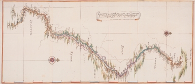
Detail View: Old Maps Collection: Chart of the river of Canton : taking Its origin, from the Tartar mountains, and passing through various Chinese provinces, until at last it discharges its water, into the great sea at Macau
|
Barcode:
|
36878003222323
|
|
Title:
|
Chart of the river of Canton : taking Its origin, from the Tartar mountains, and passing through various Chinese provinces, until at last it discharges its water, into the great sea at Macau
|
|
Original Title:
|
Caerte van de rivier, van Canton : nemende zijn beginsel, ủijt het Tartarishe gebercht, en passeerende door verfche de Sineese Provintien, tot dat hij en deling zijn water, bij Macoủw in de groote zee ủijt loft
|
|
Other Title:
|
Map of the route from Canton to Peking
|
|
Other Title:
|
Landkarte der Strecke von Kanton nach Peking auf dem Wasserweg
|
|
Contributor:
|
Vinckeboons, Joan, 1617-1670, cartographer
|
|
Category:
|
General Maps
|
|
Type:
|
Manuscripts
|
|
Language:
|
Dutch
|
|
Create Year:
|
[1668]
|
|
Format:
|
JPEG 11267 x 4845, 18.5MB
|
|
Scale:
|
Scale not given.
|
|
Note:
|
The original is a Atlas factice consisting of Joan Blaeu's 'Atlas Maior' and Van Der Hem's additions. Between 1662-1672 Joan Blaeu published his famous 'Atlas Maior' edited in Latin, French, Dutch, and Spanish, and, bound in nine to twelve volumes, depending on the edition. For over a hundred years, Blaeu's 'Atlas Maior' -with almost 600 maps and 3000 pages of text- remained the standard world atlas. Laurens van der Hem, an Amsterdam lawyer, had begun collecting maps and topographical drawings as early as 1645 and when the Latin edition of Blaeu's 'Atlas Maior' was published in 1662, he acquired a copy -in 11 volumes- which he used to make an even more ambitious collection of maps, topographical drawings and prints. Van der Hem arranged the sheets in the Atlas according to his own ideas, amplifying the volumes with more than 1800 maps, charts, townscapes, architectural prints, portraits, etc. Besides prints, the atlas also contains a wealth of drawings: maps, townscapes, seascapes, renderings of foreign people, among others always in the size of sheets from 'Atlas Maior' to maintain the harmony of the work -if too wide, they were folded in; if too small, they were enlarged, and colored in such a way that the transition from original print to enlargement became invisible; if too high, they were reduced in format, or cut into pieces, and separately pasted on blank leaves. Among the most impressive of Van der Hem's additions are the set of four volumes of manuscript-maps and drawings, which were originally made for the East Indies Company -in which this map is included. The complete work resulted in a 50-volume atlas. When Van der Hem died his children inherited the atlas, his daughter Agatha kept the Atlas for many years. After Agatha's death the atlas was auctioned by Adriaan Moetjens in The Hague in 1730, the buyer was Prince Eugene of Savoie (1663-1736), stadtholder-general of the Austrian Netherlands and a known art-lover and collector. After Eugene's death in 1736 his widow sold the Atlas to Charles VI, Holy Roman Emperor, who kept it in his Hofbibliothek, which is nowadays the Austrian National Library. In 2009 the HES & De Graaf Publishers made an 8 volume facsimile comprising volumes 35-45 of the original, limited edition of 100 sets. Although Joan Vinckeboons has never been to Asia himself he made quite a few city elevations, plans, coastal profiles and sea charts with combined information based on reports and sketches that masters, helmsmen and merchants made on their travels under the orders of the Dutch East India Company and Dutch West India Company. In this striking watercolor, it can be seen the river running from Peking to Canton, that no longer exists today. The route indicated was the one followed by the embassy of Pieter de Goyer (d. 1655) and Jacob de Keyser (fl. 1665) to the Chinese emperor. The details of the river are given with detail of small islands and with a lot of place names recorded.
|
|
Note:
|
Original is a manuscript watercolored view by Johannes Vingboons from 'The Secret Atlas of the East India Company' in the 'Atlas Blaeu-Van der Hem', 56 x 130 cm.
|
|
Note:
|
Oriented with West up.
|
|
Note:
|
Title inside banderole.
|
|
Note:
|
There are two 16-point compass roses with a fleur de lis indicating north and a cross on East point. Both are colored red, blue, magenta and gold.
|
|
Note:
|
Relief shown pictorially.
|
|
Note:
|
Map with graticule.
|
|
Note:
|
Latitude line in white, red and blue interchangeably on the bottom part of the map.
|
|
Note:
|
Map outlined in yellow and red border.
|
|
Note:
|
Macao and its surroundings.
|
|
Note:
|
Macao in China maps.
|
|
Reference:
|
Ausserer, K. Der Atlas Blaeu der Wiener National-Bibliothek, Beiträge zur historiche Geographie, p. 1-40
|
|
Reference:
|
Groot, E. de The Atlas Blaeu-Van der Hem of the Austrian National Library
Horst, K. van der The Atlas Blaeu-Van Der Hem : history of the Atlas and the making of the facsimile
|
|
Reference:
|
Explokart Research Project, https://www.explokart.eu/research/vanderhem.html
|
|
Subject:
|
Rivers
|
|
Geographic Area:
|
Beijing (China)
|
|
Geographic Area:
|
Guangzhou Shi (China)
|
|
Geographic Area:
|
China
|
|
Geographic Area:
|
Macao (China)
|
|
Relation Note:
|
Bd. 41:20, fol. 85 - 86, (20)
|
|
Pub Title:
|
The Atlas Blaeu-Van der Hem : a facsimile-edition of the unique copy preserved in the Austrian National Library, Vienna.
|
|
Pub Year:
|
2009
|
|
Pub location:
|
't Goy-Houten
|
|
Provenance:
|
Austrian National Library
|
|
Provenance:
|
http://data.onb.ac.at/rec/baa12661692
|
|
Provenance Call No.:
|
389030-F.K. KAR MAG
|
|
MUST holding:
|
https://must.primo.exlibrisgroup.com/permalink/853MUST_INST/171sgkf/alma991000811449705076
|