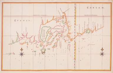
Detail View: Old Maps Collection: Map of the Chinese coast from Cabo Mandar to Nassauwen Baij
|
Barcode:
|
4687820500088
|
|
Title:
|
Map of the Chinese coast from Cabo Mandar to Nassauwen Baij
|
|
Original Title:
|
Karte des Perlflusses (Zhujiang)
|
|
Contributor:
|
Vinckeboons, Joan
|
|
Category:
|
General Maps
|
|
Type:
|
Printed
|
|
Language:
|
Dutch
|
|
Create Year:
|
1668
|
|
Format:
|
JPEG, 7428 x 4806, 10.7MB
|
|
Scale:
|
Scale not given
|
|
Note:
|
The map is a detailed representation of the southern coast of China with many bays, inlets and rivers on both sides of the Pearl River.
|
|
Note:
|
Macao and its Surroundings
|
|
Note:
|
Macao in Routes
|
|
Subject:
|
Coasts
|
|
Geographic Area:
|
Macao (China)
|
|
Geographic Area:
|
Pearl River Estuary (China)
|
|
Geographic Area:
|
Guangdong Sheng (China)
|
|
Relation Note:
|
In: Atlas Blaeu-Van der Hem, Bd. 41:18, fol. 81 - 82, (18)
|
|
Pub Title:
|
The Atlas Blaeu-Van der Hem : a facsimile-edition of the unique copy preserved in the Austrian National Library, Vienna.
|
|
Pub Author:
|
Blaeu, Joan, 1596-1673
|
|
Pub Year:
|
2009
|
|
Pub location:
|
't Goy-Houten
|
|
Provenance:
|
|