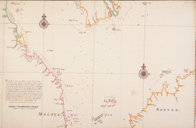
Detail View: Old Maps Collection: Map of the southern part of the South Chinese Sea
|
Barcode:
|
4687820500085
|
|
Title:
|
Map of the southern part of the South Chinese Sea
|
|
Original Title:
|
Karte des südlichen Teils des Südchinesischen Meers
|
|
Contributor:
|
Vinckeboons, Joan
|
|
Contributor:
|
Koen, Cornelis Jansz
|
|
Contributor:
|
Vries, Marten Gerritsen
|
|
Category:
|
General Maps
|
|
Type:
|
Printed
|
|
Language:
|
Dutch
|
|
Create Year:
|
1654
|
|
Format:
|
JPEG, 5601 x 4876, MB
|
|
Scale:
|
Scale not given
|
|
Note:
|
The chart was drawn in 1654 by Cornelis Jansz. Koen and copied between 1665 and 1668, probably in the studio of Johannes Vingboons.
|
|
Geographic Area:
|
South China Sea
|
|
Geographic Area:
|
Malaysia
|
|
Geographic Area:
|
Borneo
|
|
Relation Note:
|
In: Atlas Blaeu - Van der Hem, Bd. 39:27, fol. 103 - 104, (27)
|
|
Pub Title:
|
The Atlas Blaeu-Van der Hem : a facsimile-edition of the unique copy preserved in the Austrian National Library, Vienna.
|
|
Pub Author:
|
Blaeu, Joan, 1596-1673
|
|
Pub Year:
|
2009
|
|
Pub location:
|
't Goy-Houten
|
|
Provenance:
|
|