Detail View: Old Maps Collection: Map of the bay of Amoy
|
Barcode:
|
4687820500084
|
|
Title:
|
Map of the bay of Amoy
|
|
Original Title:
|
Karte der Bucht von Amoy (Xiamen Gang)
|
|
Contributor:
|
Vinckeboons, Joan
|
|
Category:
|
General Maps
|
|
Type:
|
Printed
|
|
Language:
|
Dutch
|
|
Create Year:
|
1668
|
|
Format:
|
JPEG, 6942 x 4676, 15.5MB
|
|
Scale:
|
Scale not given
|
|
Note:
|
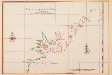
"Pascaert van de rivier Cincheo : beginnende van Texelsbaij, tot klippenbaij, Noordtwaerts op."
|
|
Note:
|
This map shows Amoy Bay (Xiamen Gang) with the islands of Amoy (Xiamen) and Quemoy (Jinmendao). The river called "Riviere Chicheo" may be either the Xiji or the Jiulongjiang.
|
|
Subject:
|
Coasts
|
|
Geographic Area:
|
Xiamen Shi (China)
|
|
Relation Note:
|
In: Atlas Blaeu-Van der Hem, Bd. 41:17, fol. 78 - 79, (17)
|
|
Pub Title:
|
The Atlas Blaeu-Van der Hem : a facsimile-edition of the unique copy preserved in the Austrian National Library, Vienna.
|
|
Pub Author:
|
Blaeu, Joan, 1596-1673
|
|
Pub Year:
|
2009
|
|
Pub location:
|
't Goy-Houten
|
|
Provenance:
|
|