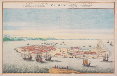
Detail View: Old Maps Collection: Bird's eye view of Tayouan and Fort Zeelandia = 大員港市鳥瞰圖
|
Barcode:
|
4687820500071
|
|
Title:
|
Bird's eye view of Tayouan and Fort Zeelandia = 大員港市鳥瞰圖
|
|
Original Title:
|
Taioan
|
|
Contributor:
|
Vinckeboons, Joan
|
|
Category:
|
City Plans & Views
|
|
Type:
|
Printed
|
|
Language:
|
Dutch
|
|
Create Year:
|
1668
|
|
Format:
|
JPEG, 7271 × 4726, 17.6MB
|
|
Scale:
|
Scale not given
|
|
Note:
|
17th century watercolor drawing of the Dutch East India Company's Fort Zeelandia on the island of Formosa. From the Eugenius-atlas, or Atlas Blaeu - Van der Hem, commissioned by Laurens van der Hem. The survey image includes a legend identifying government buildings, markets, neighbourhoods etc. Drawn no earlier than 1624.
|
|
Note:
|
Fort Zeelandia (Chinese: 熱蘭遮城; pinyin: rèlánzhē chéng) was a fortress built over ten years from 1624 to 1634 by the Dutch Verenigde Oostindische Compagnie, in the town of Anping (Tainan) on the island of Formosa (present-day Taiwan), during their 38-year rule over the western part of that island. The current name of the site in Chinese is Anping Fort (安平古堡). During the seventeenth century, when Europeans from many countries sailed to Asia to develop trade, Formosa became one of East Asia's most important transit sites, and Fort Zeelandia an international business center. On behalf of the Dutch East India Company, ships departed from Formosa and headed north to Japan, west to Fujian, or south to Vietnam, Thailand, Indonesia, India, Iran or Europe.
|
|
Geographic Area:
|
Taiwan
|
|
Relation Note:
|
In: Atlas Blaeu-Van der Hem, Bd. 41:05, fol. 44 - 45, (4)
|
|
Pub Title:
|
The Atlas Blaeu-Van der Hem : a facsimile-edition of the unique copy preserved in the Austrian National Library, Vienna.
|
|
Pub Author:
|
Blaeu, Joan, 1596-1673
|
|
Pub Year:
|
2009
|
|
Pub location:
|
't Goy-Houten
|
|
Provenance:
|
|