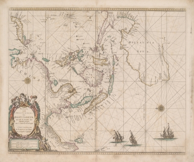
Detail View: Old Maps Collection: Paskaerte Zynde t'Oosterdeel Van Oost Indien : met alle de Eylanden deer ontrendt geleegen van C. Comorin tot aen Japan

|
Barcode:
|
4687820500802
|
|
Title:
|
Paskaerte Zynde t'Oosterdeel Van Oost Indien : met alle de Eylanden deer ontrendt geleegen van C. Comorin tot aen Japan
|
|
Original Title:
|
Paskaerte Zynde t'Oosterdeel Van Oost Indien : met alle de Eylanden daer ontrendt geleegen van C. Comorin tot aen Iapan
|
|
Contributor:
|
Goos, Pieter, approximately 1616-1675
|
|
Category:
|
Sea Charts
|
|
Type:
|
Printed
|
|
Language:
|
Dutch
|
|
Create Year:
|
1666
|
|
Format:
|
JPEG2000, 7460 × 7520, 77.4MB
|
|
Scale:
|
[ca. 1:18 000 000]
|
|
Physical Map Dimension (cm):
|
43 × 53.9
|
|
Note:
|
Map of Indonesia, South East Asia, China, Japan and north west Australia; Southern Australian coast to St. Francis Isles. Tasmania omitted. Known Shipwrecks marked.
|
|
Reference:
|
Koeman, Goos 1 Tooley, 670.
|
|
Geographic Area:
|
Australia
|
|
Geographic Area:
|
Indonesia
|
|
Geographic Area:
|
Southeast Asia
|
|
Relation Note:
|
From : De Zee-Atlas ofte Water-Weereld ... By Pieter Goos, ... 1666.
|
|
Pub Title:
|
De Zee-Atlas ofte Water-Weereld
|
|
Pub Author:
|
Goos, Pieter, approximately 1616-1675
|
|
Pub Year:
|
1666
|
|
Pub location:
|
Amsterdam
|
|
Provenance:
|
National Library of Australia
|