Detail View: Old Maps Collection: Australien (Südland) auch Polynesien oder Inselwelt, insgemein der fünfte Welttheil genannt : nach den neuesten und bewährtesten Hülfsmitteln entworfen
|
Barcode:
|
36878003222402
|
|
Title:
|
Australien (Südland) auch Polynesien oder Inselwelt, insgemein der fünfte Welttheil genannt : nach den neuesten und bewährtesten Hülfsmitteln entworfen
|
|
Contributor:
|
Walch, Johannes, 1757-1816, cartographer
|
|
Category:
|
General Maps
|
|
Type:
|
Printed
|
|
Language:
|
German
|
|
Create Year:
|
1802
|
|
Format:
|
JPEG 2000, 8101 × 7568, 89MB
|
|
Scale:
|
[ca. 1:30,000,000].
|
|
Physical Map Dimension (cm):
|
48 x 60 cm
|
|
Note:
|
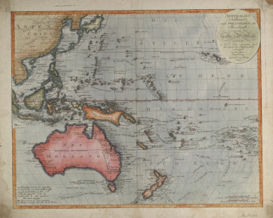
The map depicts Australia -here named Neu Holland-, South East Asia and the South West Pacific, Japan and western China. It celebrates the routes and encounters of the recent European voyages to the region, shows tracks of Cook, Tasman, Marshall, Bougainville, Carteret, Byron and other explorers. Australia, New Zealand, and the island Pacific have a lot of place names identified, and numerous tiny islands are named as far east as French Polynesia. New Zealand marks out the southern reaches of the map, with Japan and Korea in the north. The rudimentary shape of New Guinea reflects the little charting that took place there by 1802. New Zealand is shown as two islands labelled with it's Maori names. On the bottom left corner of the map there is a note stating that in the map it can be seen three sea trips of the Captain Cook, and other circumnavigators; that the direction of this is shown by small posts or arrows. The map reflects the booming German market in the Pacific region after Cook's voyages. The Germans themselves would start to explore the region in the 19th century and the German Empire would eventually encompass German New Guinea from 1884 to 1919.
|
|
Note:
|
Original is a copperplate printed map, water colored by hand, 48 x 60 cm.
|
|
Note:
|
Title in oval cartouche on the top left corner of the map.
|
|
Note:
|
Double scale line on the bottom right side corner of the map, colored red.
|
|
Note:
|
Different countries colored in different colors.
|
|
Note:
|
Water masses colored blue.
|
|
Note:
|
Four borders of the map with longitude and latitude lines in black and white interchangeably. Equator line in red.
|
|
Note:
|
Macao in Routes.
|
|
Reference:
|
Tooley's Dic. of Mapmakers, Q-Z [vol. 4], p. 343
|
|
Reference:
|
Tooley, R.V. Mapping of Australia and Antarctica, 1309, pl. 149
|
|
Reference:
|
Worth, L.C. The Early Cartography of the Pacific, The Papers of the Bibliographical Society of America 38, no. 2 (1944), p. 87-268
|
|
Reference:
|
Morison, S.E. The Gilberts and Marshalls: A Distinguished Historian Recalls the Past of Two Recently Captured Pacific Groups, Time (May 22, 1944),p. 91-101
|
|
Reference:
|
Sammet, G. Die Welt der Karten: historische und moderne Kartographie im Dialog, p. 48-49
|
|
Reference:
|
Suárez, T. Early Mapping of the Pacific
|
|
Reference:
|
Clancy, R. The Mapping of Terra Australis
|
|
Geographic Area:
|
Australia
|
|
Geographic Area:
|
Indonesia
|
|
Geographic Area:
|
Islands of the Pacific
|
|
Geographic Area:
|
Pacific Ocean
|
|
Geographic Area:
|
China
|
|
Geographic Area:
|
Taiwan
|
|
Geographic Area:
|
Vietnam
|
|
Geographic Area:
|
Paracel Islands
|
|
Geographic Area:
|
Korea
|
|
Geographic Area:
|
Japan
|
|
Geographic Area:
|
Borneo
|
|
Geographic Area:
|
Philippines
|
|
Geographic Area:
|
Southeast Asia
|
|
Geographic Area:
|
Papua New Guinea
|
|
Geographic Area:
|
Oceania
|
|
Provenance:
|
National Library of Australia
|
|
Provenance:
|
https://nla.gov.au/nla.cat-vn1114918
|
|
Provenance Call No.:
|
MAP NK 1546.
|
|
MUST holding:
|
https://must.primo.exlibrisgroup.com/permalink/853MUST_INST/reglfj/alma991002923949705076
|