Detail View: Old Maps Collection: Macao : fose ficada mais dez anos depois que enemigos de Europa foram della para tomarem
|
Barcode:
|
4687820500799
|
|
Title:
|
Macao : fose ficada mais dez anos depois que enemigos de Europa foram della para tomarem
|
|
Other Title:
|
Macau : fosse ficada mais dez anos depois que inimigos da Europa foram dela para tomarem
|
|
Contributor:
|
Pacia, Vicente, 1880-1940, attributed name
|
|
Contributor:
|
Braga, José Maria, 1897-1988, former owner
|
|
Category:
|
City Plans & Views
|
|
Type:
|
Printed
|
|
Language:
|
Portuguese
|
|
Create Year:
|
[ca. 1940]
|
|
Format:
|
JPEG2000, 4676 × 3244, 25.8MB
|
|
Scale:
|
Scale not given (E 113°32'47"/N 22°11'59")
|
|
Physical Map Dimension (cm):
|
19 x 29 cm, on sheet 23 x 34 cm
|
|
Note:
|
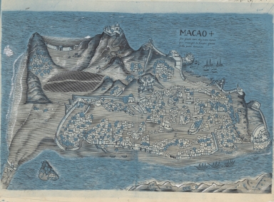
The map belongued to José Maria Braga (1897-1988)-or Jack Braga, chinese name 白樂嘉- a Hongkonger of Portuguese ascending. Braga was an English Literature Professor at St. Joseph's Seminary but when he moved to Macao in 1924 took a keen interest in its history. During the 22 years he lived there he researched and published about Macao's history and the role of the Portuguese in its development. He also developed an important library on the history of the West and East encounters. This library composed of books, manuscripts, maps, pictures, newspapers and journals was acquired by both the Biblioteca Pública de Macau and the National Library of Australia. In 1966 -with the author still alive- the National Library of Australia acquired the bulk of the library with 6000 monographs and other materials in which this map is included. Braga was offered an honorarium by said Library to work on the organisation of this collection but became ill and couldn't finish this task. This was probably drawn by Vicente Pacia -a Philippine born well-known for 200 or so watercolors of Macao- from an original by Pedro Barreto de Resende (15---1651) in 'Livro das Plantas de todas as fortalezas, cidades e povoaçoens do Estado da Índia Oriental'. The view emphasizes the city walls and several fortresses, with the text in allegory to the unsuccessful Dutch attack in 1622. In the foreground is the Inner Harbour with a few vessels in it, and the small Green Island on the left.
|
|
Note:
|
Original is a hand-drawn map, 22 x 34 cm.
|
|
Note:
|
Oriented with East at the top.
|
|
Note:
|
Relief shown pictorially and by shading.
|
|
Note:
|
City plans of Macao.
|
|
Subject:
|
Aerial views
|
|
Subject:
|
Pictorial maps
|
|
Geographic Area:
|
Macao (China)
|
|
Provenance:
|
National Library of Australia
|
|
Provenance:
|
https://nla.gov.au/nla.cat-vn3107874
|
|
Provenance Call No.:
|
MAP Braga Collection Col./108
|
|
MUST holding:
|
https://must-primo.exlibris.com.cn/permalink/853MUST_INST/reglfj/alma991002940149805076
|