Detail View: Old Maps Collection: Japan, the islands of Loochoo & Formosa, and the maritime provinces of China with the tract of the Morrison's voyage in 1837
|
Barcode:
|
4687820500798
|
|
Title:
|
Japan, the islands of Loochoo & Formosa, and the maritime provinces of China with the tract of the Morrison's voyage in 1837
|
|
Original Title:
|
Japan, the islands of Loochoo & Formosa, and the maritime provinces of China with the tract of the Morrison's voyage in 1837
|
|
Contributor:
|
Arrowsmith, John, 1790-1873
|
|
Category:
|
Thematic Maps
|
|
Type:
|
Printed
|
|
Language:
|
English
|
|
Create Year:
|
1847
|
|
Format:
|
JPEG2000, 13704 × 11065, 153.9MB
|
|
Scale:
|
[1:6,100,000 at 30°N] (E 112°--E 144°/N 42°--N 22°)
|
|
Physical Map Dimension (cm):
|
42 × 53
|
|
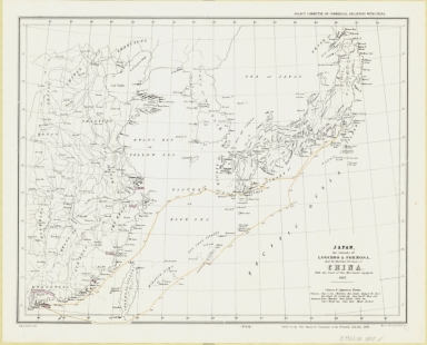
Note:
|
Map of Nipon [i.e. Japan] and its provinces as well as the Loochoo [i.e. Ryukyu] Islands and to the west the Kingdom of Correa [i.e. Korea], Formosa Island [i.e. Taiwan] and the northeast portion of China and its provinces. The map features a time-dated route in yellow of an unarmed ship the Morrison used in an attempt to make peaceful contact with Japanese authorities hostile to the West. In July of 1837 several American missionaries and an American firm (D.W.C. Olyphant and Co.) in Canton, China dispatched the Morrison from Macau, China to Yedo [i.e. Tokyo] Bay. The mission, lead by Charles W. King, an American merchant, was to return several Japanese castaways and through this humanitarian gesture hopefully cause the Japanese to open the country to Western trade and Christianity. The Dutch were aware of the Morrison mission and gave the Japanese advance notice of the impending visit. The Japanese promptly signaled the visit would not be allowed when the ship reached Japanese waters. The Morrison was fired on by shore batteries while sitting off Uraga [i.e. Yokohama] and again in the Bay of Kagoshima. One shot hit the Morrison but caused no injury and only minor damage to the ship. The mission was abandoned. At top right corner of sheet: Select Committee on Commercial Relations with China. At bottom right corner of sheet: Ordered by the House of Commons to be printed, 12th July, 1847. At bottom centre of sheet: "(No. 654)" Includes legend entitled: Chinese & Japanese Terms. Original version: [London?] : J. Arrowsmith Lith., [1847], (Henry Hansard, printer).
|
|
Subject:
|
Morrison (Ship)
|
|
Geographic Area:
|
East Asia
|
|
Geographic Area:
|
Japan
|
|
Relation Note:
|
Map 36 from: Catalog of maps of China & Japan, 1837-1899. [Dublin, Ireland?] : Irish Academy Press, [1978?]
|
|
Pub Title:
|
Catalog of maps of China & Japan, 1837-1899
|
|
Pub Year:
|
1978?
|
|
Pub location:
|
[Dublin, Ireland?]
|
|
Provenance:
|
National Library of Australia
|