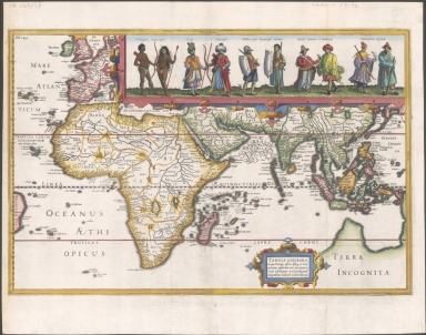
Detail View: Old Maps Collection: Tabula geograph. in qua Europae, Africae, Asiaeq[ue] et circujacentium insularum orae maritimae accuratè describuntur et ad intelligentia navigationum Indicaru[m] accommodantu

|
Barcode:
|
3687800354095F
|
|
Title:
|
Tabula geograph. in qua Europae, Africae, Asiaeq[ue] et circujacentium insularum orae maritimae accuratè describuntur et ad intelligentia navigationum Indicaru[m] accommodantu
|
|
Contributor:
|
Pontanus, Johannes Isacius, 1571-1639, cartographer
|
|
Contributor:
|
Hondius, Jodocus, 1563-1612, engraver, printer
|
|
Category:
|
General Maps
|
|
Type:
|
Printed
|
|
Language:
|
Latin
|
|
Language:
|
Portuguese
|
|
Create Year:
|
[1611]
|
|
Format:
|
JPEG 2000, 5191 × 4086, 37MB
|
|
Page No.:
|
4
|
|
Scale:
|
[ca. 1:80,000,000].
|
|
Physical Map Dimension (cm):
|
27 x 41 cm, on sheet 36 x 50 cm
|
|
Note:
|
This is a rare map from 'Rerum et Urbis Amstelodamensium Historia' -placed right before fol. 145- by Johannes Isacius Pontanus apparently engraved by Jodocus Hondius. The map extends from western Europe to Japan with all Africa, Arabia and Southern Asia. It shows the route of Dutch merchants to the Indies for it celebrates the opening of the sea routes from Europe to the Dutch East Indies, following the voyage of Cornelis Houtman in 1597. Houtman's expedition, which passed through the Sunda Strait, by passing the Portuguese controlled Malacca Strait and thereby opening up trading opportunities for Dutch traders in the region, assuring the ascent of Amsterdam to a world trading power and commerce center. Includes an inset with costumed figures showing native representations of people from: Ethiopia, Guinea, Persia, Turkey, Molucas, Java, Sumatra, Mallaca and China.
|
|
Note:
|
Original map is copperplate printed, colored by hand, 26 x 41 cm.
|
|
Note:
|
Both the title and the natives representations inside strapwork cartouches.
|
|
Note:
|
Relief shown pictorially.
|
|
Note:
|
Latitude line on the left border of the map and Equator as longitude line. Tropic of Cancer and Capricorn in red.
|
|
Note:
|
The four borders of the map labelled with North, South, East and West in Latin Septentrio (Septentriones), Meridies, Occidens and Oriens respectively.
|
|
Note:
|
Continents outlined in different colors. Islands colored yellow, green and pink.
|
|
Note:
|
Map outlined in fivefold fillet colored yellow.
|
|
Note:
|
Macao in East Indies Maps.
|
|
Note:
|
Title, legends, land masses and water masses in Latin but place names in Portuguese.
|
|
Reference:
|
Nordenskiöld, A.E. v. 3, 635
|
|
Geographic Area:
|
Eastern Hemisphere
|
|
Geographic Area:
|
Indian Ocean
|
|
Geographic Area:
|
Asia
|
|
Geographic Area:
|
Southeast Asia
|
|
Geographic Area:
|
Africa
|
|
Geographic Area:
|
Australia
|
|
Relation Note:
|
[pl. 4]
|
|
Pub Title:
|
Rerum Et Urbis Amstelodamensium Historia
|
|
Pub Author:
|
Pontanus, Johannes Isacius, 1571-1639
|
|
Pub Year:
|
1611
|
|
Pub location:
|
Amsterdam
|
|
Provenance:
|
National Library of Australia
|
|
Provenance:
|
https://nla.gov.au/nla.cat-vn1916493
|
|
Provenance Call No.:
|
MAP RM 3289
|
|
MUST holding:
|
https://must.primo.exlibrisgroup.com/permalink/853MUST_INST/171sgkf/alma991002923848205076
|