Detail View: Old Maps Collection: Map of the Sun-On-District, (Kwangtung Province) = 新安縣全圖
|
Barcode:
|
4687820500787
|
|
Title:
|
Map of the Sun-On-District, (Kwangtung Province) = 新安縣全圖
|
|
Original Title:
|
Map of the Sun-On-District, (Kwangtung Province) = 新安縣全圖
|
|
Contributor:
|
Volonteri, Simeone, 1831-1904
|
|
Contributor:
|
Brockhaus, F. A
|
|
Category:
|
General Maps
|
|
Type:
|
Manuscripts
|
|
Language:
|
English
|
|
Language:
|
Chinese
|
|
Create Year:
|
1866
|
|
Format:
|
JPEG2000, 26156 × 21129, 165.8MB
|
|
Scale:
|
[ca. 1:106,445] (E 114°50'--E 115°40'/N 22°10'--N 22°45')
|
|
Physical Map Dimension (cm):
|
85.4 × 107.3
|
|
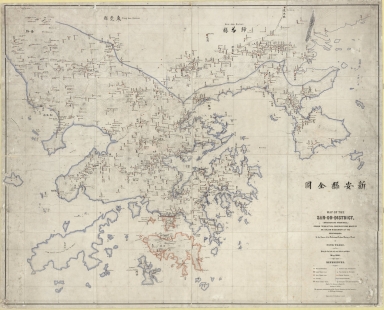
Note:
|
Map of the San-On district within the Kwangtung Province and featuring the city of Hong Kong following British occupation in 1841. The boundary of the British colony is shown in Kowloon. This peninsula had been added to the colony of Hong Kong in 1860. Place names are given in both Roman and Chinese scripts. In 1860 Monsigneur Simeone Volonteri joined the Mission of the Propaganda in the Roman Catholic Diocese of Hong Kong and while there produced this map. "The uncertain pronunciation of the Chinese characters is fixed according to Williams's Dictionary".
|
|
Geographic Area:
|
Guangdong Sheng (China)
|
|
Geographic Area:
|
Hong Kong (China)
|
|
Pub Title:
|
The San On map of Mgr. Volonteri
|
|
Pub Author:
|
Volonteri, Simeone, 1831-1904
|
|
Pub Author:
|
Ng, Ronald C. Y., 1938-
|
|
Pub Year:
|
1866?
|
|
Provenance:
|
National Library of Australia
|