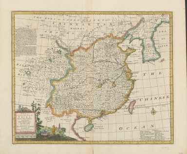
Detail View: Old Maps Collection: A new & accurate map of China : drawn from surveys made by Jesuit missionaries by order of the Emperor : the whole being regulated by numerous astronomical observations

|
Barcode:
|
4687820500786
|
|
Title:
|
A new & accurate map of China : drawn from surveys made by Jesuit missionaries by order of the Emperor : the whole being regulated by numerous astronomical observations
|
|
Original Title:
|
A new & accurate map of China : drawn from surveys made by Jesuit missionaries by order of the Emperor : the whole being regulated by numerous astronomical observations
|
|
Contributor:
|
Bowen, Emanuel, -1767
|
|
Category:
|
General Maps
|
|
Type:
|
Printed
|
|
Language:
|
English
|
|
Create Year:
|
1747
|
|
Format:
|
JPEG2000, 5638 × 4777, 42.8MB
|
|
Scale:
|
[1:8,945,000] (E 92°--E 130°/N 44°--N 16°)
|
|
Physical Map Dimension (cm):
|
32.8 × 40.4
|
|
Note:
|
Map of China showing its provinces but without clear boundaries and including to the west the Kingdom of Tibet & Mogols of Kokonor stretching to the Kingdom of Corea [i.e. Korea] in the east. The map also includes the Isle of Hay Nan [i.e. Hainan] and the island of Taewan (or Formosa). Bowen has gone to considerable trouble to indicate the major river systems with a considerable degree of accuracy, though elaborate details of physical features in Tibet are largely conjectural'. The cartouche portrays a walled city with an elaborate pagoda. In the foreground a mandarin dispensing justice is identifiable by his dress and headgear, thus pointing out that, unlike other newly discovered lands, this distant and unknown country was civilised and had a highly developed system of justice. A modest compass rose is also shown. Cartouche title. Text reviewing the history of European cartography of China by Jesuit missionaries from 1708-1717 is included and entitled: Advertisement At bottom left corner of sheet: No. 41.
|
|
Geographic Area:
|
China
|
|
Relation Note:
|
Map no. 41 from: A complete system of geography / by Emanuel Bowen. London : Printed for W. Innys [and others], 1747.
|
|
Pub Title:
|
A complete system of geography
|
|
Pub Author:
|
Bowen, Emanuel, 1693 or 1694-1767
|
|
Pub Year:
|
1747
|
|
Pub location:
|
London
|
|
Provenance:
|
National Library of Australia
|