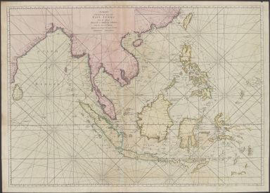
Detail View: Old Maps Collection: A chart of the eastermost part of the East Indies from the island Zeloan to Amoy in China : with the adjacent islands adjusted according to the most accurate astronomical observations
|
Barcode:
|
4687820500785
|
|
Title:
|
A chart of the eastermost part of the East Indies from the island Zeloan to Amoy in China : with the adjacent islands adjusted according to the most accurate astronomical observations
|
|
Original Title:
|
A chart of the eastermost part of the East Indies from the island Zeloan to Amoy in China : with the adjacent islands adjusted according to the most accurate astronomical observations
|
|
Contributor:
|
Seller, John, active 1658-1698
|
|
Category:
|
Sea Charts
|
|
Type:
|
Printed
|
|
Language:
|
English
|
|
Create Year:
|
1671
|
|
Format:
|
JPEG2000, 9793 × 7022, 86.2MB
|
|
Scale:
|
[ca.1:85,000,000]
|
|
Physical Map Dimension (cm):
|
54.8 × 77.5
|
|
Note:
|
Map of the East Indies showing the coast of India, Malaysia, Philippines and the Indonesian archipelago. The top of Australia is shown as the Southern Land.
|
|
Subject:
|
Nautical charts
|
|
Geographic Area:
|
Southeast Asia
|
|
Geographic Area:
|
Philippines
|
|
Geographic Area:
|
Indonesia
|
|
Relation Note:
|
From v. III of : The English pilot / John Seller. London, 1671.
|
|
Pub Title:
|
The English pilot
|
|
Pub Author:
|
Seller, John, active 1658-1698
|
|
Pub Year:
|
1671
|
|
Pub location:
|
London
|
|
Provenance:
|
National Library of Australia
|