Detail View: Old Maps Collection: Nova tabula India Orientalis
|
Barcode:
|
3687800239546I
|
|
Title:
|
Nova tabula India Orientalis
|
|
Original Title:
|
Nova tabvla India Orientalis
|
|
Contributor:
|
Allard, Carel, 1648-ca. 1709, cartographer
|
|
Category:
|
General Maps
|
|
Type:
|
Printed
|
|
Language:
|
Latin
|
|
Language:
|
Portuguese
|
|
Language:
|
Spanish
|
|
Language:
|
French
|
|
Language:
|
Dutch
|
|
Create Year:
|
[ca. 1690]
|
|
Format:
|
JPEG 2000, 7113 × 6098, 52.6MB
|
|
Scale:
|
[ca. 1:30,000,000].
|
|
Physical Map Dimension (cm):
|
42 x 52 cm, on sheet 58 x 82 cm
|
|
Note:
|
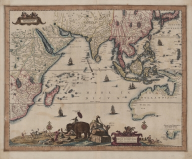
In this map it is depicted Australia, Van Diemens Land and Japan in the East to the Indian Ocean, Cape of Good Hope and the region around the Red Sea in the west. Van Diemen's Land it shown in too large a proportion to the rest of Australia, which has still not been established as being separate from Papua New Guinea. The map was first issued by Hugo Allard in ca. 1660 and this is a reissue by his son, Carel Allard, with the only change being the authors name. All of Allard's maps are rare for the print run was in small number and the striking rococo embellishments are much appreciated by the collectors. There are some notes on Australia -here named 'Nova Hollandia'- of the Dutch discoveries on the coastline.
|
|
Note:
|
Original is a copper plate printed map water coloured by hand, 42 x 53 cm.
|
|
Note:
|
Title in an ornamented cartouche with a cherub on top. On the left there is a scene of Asian merchants and traders with elephants and camels carrying packed trade goods. There is also a depiction of a native African ostrich hunt.
|
|
Note:
|
Depicted are six western sail ships on the map. There are two compass roses on the map with a fleur-de-lis indicating north and a cross on east point; both colored yellow, black and red.
|
|
Note:
|
Scale line in German miles inside a cartouche with two cherubs on top.
|
|
Note:
|
Relief shown pictorially.
|
|
Note:
|
Land masses outlined in different colours.
|
|
Note:
|
The four borders of the map with latitude and longitude lines in black and white interchangeably.
|
|
Note:
|
Map outlined in triple fillet.
|
|
Note:
|
Macao in East Indies maps.
|
|
Note:
|
Title, scale line, land and water masses, the Tropics and Equator in Latin with place names in Portuguese, Spanish and French. Some notes on 'Nova Hollandia' in both Latin and Dutch.
|
|
Reference:
|
Tooley's Dic. of mapmakers, A-D [vol. 1], p. 21
|
|
Reference:
|
Tooley, R.V. Maps and map-makers, (Australia), 49, p. 207
|
|
Geographic Area:
|
Indian Ocean
|
|
Geographic Area:
|
East Indies
|
|
Geographic Area:
|
Asia
|
|
Geographic Area:
|
Africa, East
|
|
Geographic Area:
|
Madagascar
|
|
Geographic Area:
|
Ceylon
|
|
Geographic Area:
|
India
|
|
Geographic Area:
|
Malaysia
|
|
Geographic Area:
|
Indonesia
|
|
Geographic Area:
|
Thailand
|
|
Geographic Area:
|
Cambodia
|
|
Geographic Area:
|
Vietnam
|
|
Geographic Area:
|
Paracel Islands
|
|
Geographic Area:
|
Borneo
|
|
Geographic Area:
|
China
|
|
Geographic Area:
|
Korea
|
|
Geographic Area:
|
Japan
|
|
Geographic Area:
|
Philippines
|
|
Geographic Area:
|
Papua New Guinea
|
|
Geographic Area:
|
Hainan Island (China)
|
|
Geographic Area:
|
Taiwan
|
|
Geographic Area:
|
Australia
|
|
Provenance:
|
National Library of Australia
|
|
Provenance:
|
https://nla.gov.au/nla.cat-vn587828
|
|
Provenance Call No.:
|
MAP NK 1578
|
|
MUST holding:
|
https://must.primo.exlibrisgroup.com/permalink/853MUST_INST/reglfj/alma991000435339705076
|