Detail View: Old Maps Collection: Planta da colonia portugueza de Macau e dos seus portos internos e externos, com indicação dos postos aduaneiros chineses modernamente estabelecidos
|
Barcode:
|
4687820500778
|
|
Title:
|
Planta da colonia portugueza de Macau e dos seus portos internos e externos, com indicação dos postos aduaneiros chineses modernamente estabelecidos
|
|
Other Title:
|
Planta da colónia portuguesa de Macau e dos seus portos internos e externos, com indicação dos postos aduaneiros chineses modernamente estabelecidos
|
|
Contributor:
|
Coutinho, Manuel de Azevedo, 1838-1903, cartographer
|
|
Contributor:
|
Portugal. Imprensa Nacional. Litografia, lithographer
|
|
Category:
|
Thematic Maps
|
|
Type:
|
Printed
|
|
Language:
|
Portuguese
|
|
Create Year:
|
1909
|
|
Format:
|
JPEG 2000, 5216 × 7957, 54MB
|
|
Scale:
|
[ca. 1:54,700] (E 113°32'47"/N 22°11'59")
|
|
Physical Map Dimension (cm):
|
23 x 18 cm, on sheet 37 x 24 cm
|
|
Note:
|
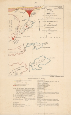
This map is from the Braga Collection at the National Library of Australia. José Maria Braga -or Jack Braga, chinese name 白樂嘉- a Hongkonger of Portuguese ascending. Braga was an English Literature Professor at St. Joseph's Seminary but when he moved to Macao in 1924 took a keen interest in its history. During the 22 years he lived there he researched and published about Macao's history and the role of the Portuguese in its development. He also developed an important library on the history of the West and East encounters. This library composed of books, manuscripts, maps, pictures, newspapers and journals was acquired by both the Biblioteca Pública de Macau and the National Library of Australia. In 1966 -with the author still alive- the National Library of Australia acquired the bulk of the library with 6000 monographs and other materials in which this map is included. Braga was offered an honorarium by said Library to work on the organisation of this collection but became ill and couldn't finish this task. This map depicts the territories of Macao and China, Chinese posts in July 1870 and Portuguese forts. It delimits in red the neutral zone north of Border Gate occupied by the Chinese authorities between 1849 and 1890. The map is from a time when the Portuguese administration of the territory had become more secure so disputes and tensions happened between those years.
|
|
Note:
|
Original is a colored printed map, 30 x 24 cm.
|
|
Note:
|
4-point compass rose with an arrow indicating north.
|
|
Note:
|
Underneath the map there is an extensive legend about Chinese tax posts, Portuguese fortresses, Macao toponyms, etc.
|
|
Note:
|
Scale line in maritime miles.
|
|
Note:
|
Macau, Taipa and Coloane outlined in blue ,meaning the territory under Portuguese administration. And 'Ilha de Hian-chan', 'Ilha da Lapa', 'Ilha de D. João' and 'Ilha de Tai-Vong-Cam' outlined in pink, as territory without constituted authority according to the legend.
|
|
Note:
|
Relief shown pictorially and by form lines.
|
|
Note:
|
Map outlined in double fillet.
|
|
Note:
|
Macao and its surroundings.
|
|
Reference:
|
Braga, S. Making Impressions : The adaptation of a Portuguese family to Hong Kong, 1700-1950, p. 75
|
|
Geographic Area:
|
Macao (China)
|
|
Provenance:
|
National Library of Australia
|
|
Provenance:
|
https://nla.gov.au/nla.cat-vn3105174
|
|
Provenance Call No.:
|
MAP Braga Collection Col./71/4
|
|
MUST holding:
|
https://must.primo.exlibrisgroup.com/permalink/853MUST_INST/171sgkf/alma991002943549705076
|