Detail View: Old Maps Collection: Carta hydrografica da Colonia de Macau
|
Barcode:
|
4687820500774
|
|
Title:
|
Carta hydrografica da Colonia de Macau
|
|
Original Title:
|
Carta hidrográfica da colónia de Macau
|
|
Other Title:
|
Panorama de Macau e ilhas visto do ponto 'A'
|
|
Other Title:
|
Porto exterior de Macau
|
|
Other Title:
|
Porto de Coloane
|
|
Contributor:
|
Macau. Obras dos Portos
|
|
Contributor:
|
Braga, José Maria, 1897-1988, former owner
|
|
Category:
|
Sea Charts
|
|
Type:
|
Printed
|
|
Language:
|
Portuguese
|
|
Create Year:
|
[ca. 1929]
|
|
Format:
|
JPEG2000, 5609 × 7730, 55.8MB
|
|
Scale:
|
[ca. 1:60,000] (E 113°27'--E 113°37'/N 22°19'--N 22°05')
|
|
Physical Map Dimension (cm):
|
39 x 27 cm, on sheet 42 x 31 cm
|
|
Note:
|
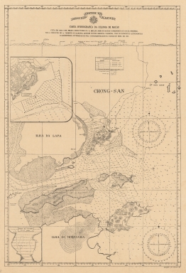
his map is from the Braga Collection at the National Library of Australia. José Maria Braga -or Jack Braga, chinese name 白樂嘉- a Hongkonger of Portuguese ascending. Braga was an English Literature Professor at St. Joseph's Seminary but when he moved to Macao in 1924 took a keen interest in its history. During the 22 years he lived there he researched and published about Macao's history and the role of the Portuguese in its development. He also developed an important library on the history of the West and East encounters. This library composed of books, manuscripts, maps, pictures, newspapers and journals was acquired by both the Biblioteca Pública de Macau and the National Library of Australia. In 1966 -with the author still alive- the National Library of Australia acquired the bulk of the library with 6000 monographs and other materials in which this map is included. Braga was offered an honorarium by said Library to work on the organisation of this collection but became ill and couldn't finish this task. Hydrographic chart of Macau with insets of the side view of Macao, of the Outer Harbour of Macao and the Harbour of Coloane. The main map and insets 2 and 3 give soundings recorded between 1928-1929 in the recently completed and dredged Outer Harbour and the narrow channel between Coloane and Chinese island of 'Montanha'.
|
|
Note:
|
Inset 1: Panorama de Macau e ilhas visto do ponto 'A'. - 1 x 25 cm. -- Inset 2: Porto exterior de Macau. - Scale 1:12,500. - 10 x 9 cm. -- Inset 3: Porto de Coloane. - Scale 1: 10,000. - 5 x 5 cm.
|
|
Note:
|
Original is a printed map, 44 x 30 cm.
|
|
Note:
|
Coat of arms of Portugal at the head of the map. Two magnetic declination compasses with a star indicating north. Legend box for the main map on 'Chong-San' and for the 'Porto exterior de Macau' inset on the Outer Harbour.
|
|
Note:
|
On the right bottom corner: "Delineador Luis Domingos Luy".
|
|
Note:
|
The four borders of the map with latitude and longitude lines.
|
|
Note:
|
Relief shown by hachures and bathymetric relfief by soundings and isolines.
|
|
Note:
|
Map with graticule.
|
|
Note:
|
Map outlined in simple fillet and inset 2 and 3 in triple fillet.
|
|
Note:
|
Macao and its surroundings.
|
|
Note:
|
City plans of Macao.
|
|
Subject:
|
Nautical charts
|
|
Geographic Area:
|
Macao (China)
|
|
Provenance:
|
National Library of Australia
|
|
Provenance:
|
https://nla.gov.au/nla.cat-vn4509039
|
|
Provenance Call No.:
|
MAP Braga Collection Col./90
|
|
MUST holding:
|
https://must-primo.exlibris.com.cn/permalink/853MUST_INST/reglfj/alma991002943749405076
|