Detail View: Old Maps Collection: China ao sul de Cantão
|
Barcode:
|
4687820500771
|
|
Title:
|
China ao sul de Cantão
|
|
Other Title:
|
Hong Kong and the approaches by river to Canton
|
|
Other Title:
|
Macao
|
|
Contributor:
|
Pacia, Vicente, 1880-1940, cartographer
|
|
Contributor:
|
Braga, José Maria, 1897-1988, creator, former owner
|
|
Category:
|
General Maps
|
|
Type:
|
Manuscripts
|
|
Language:
|
Portuguese
|
|
Create Year:
|
1928
|
|
Format:
|
JPEG2000, 7149 × 5605, 57.9MB
|
|
Scale:
|
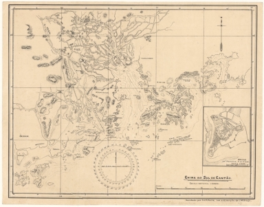
Hong Kong and the approaches by river to Canton. - Scale 1:600,000 (E 113°00'--E 115°00'/N 23°00'--N 22°00')
|
|
Scale:
|
Macao. - Scale 1:50,000.
|
|
Physical Map Dimension (cm):
|
31 x 41 cm
|
|
Note:
|
The map is drawn by Vicente Pacia -a Philippine born well-known for 200 or so watercolors of Macao- under the direction of José Maria Braga -or Jack Braga, chinese name 白樂嘉- a Hongkonger of Portuguese ascending. Braga was an English Literature Professor at St. Joseph's Seminary but when he moved to Macao in 1924 took a keen interest in its history. During the 22 years he lived there he researched and published about Macao's history and the role of the Portuguese in its development. He also developed an important library on the history of the West and East encounters. This library composed of books, manuscripts, maps, pictures, newspapers and journals was acquired by both the Biblioteca Pública de Macau and the National Library of Australia. In 1966 -with the author still alive- the National Library of Australia acquired the bulk of the library with 6000 monographs and other materials in which this map is included. Braga was offered an honorarium by said Library to work on the organisation of this collection but became ill and couldn't finish this task. The map depicts in detail China south to Guangzhou.
|
|
Note:
|
Original is a manuscript map by Vicente Pacia under the direction of José Maria Braga, 31 x 41 cm.
|
|
Note:
|
The map has both latitude and longitude lines and a compass rose at the upper right side indicating north. On the bottom there is a magnetic declination compass, 18 cm in diam.
|
|
Note:
|
Both the map and the inset have relief shown by hachures and bathymetric isolines.
|
|
Note:
|
Map and inset outlined in double fillet.
|
|
Note:
|
Macao and its Surroundings
|
|
Note:
|
City plans of Macao.
|
|
Reference:
|
The Portuguese in Asia and the Far East: the Braga collection https://www.nla.gov.au/braga-collection/portuguese-in-asia
|
|
Geographic Area:
|
Guangdong Sheng (China)
|
|
Geographic Area:
|
Macao (China)
|
|
Geographic Area:
|
Hong Kong Island (China)
|
|
Provenance:
|
National Library of Australia
|
|
Provenance:
|
https://nla.gov.au/nla.cat-vn3106780
|
|
Provenance Call No.:
|
MAP Braga Collection Col.63
|
|
MUST holding:
|
https://must.primo.exlibrisgroup.com/permalink/853MUST_INST/171sgkf/alma991000818289705076
|