Detail View: Old Maps Collection: 山東全圖 = Shantung
|
Barcode:
|
4687820500739
|
|
Title:
|
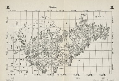
山東全圖 = Shantung
|
|
Original Title:
|
山東全圖 = Shantung
|
|
Contributor:
|
Regis, Jean Baptiste, 1664-1738
|
|
Contributor:
|
Fuchs, Walter, 1902-1979
|
|
Contributor:
|
Jartoux, Pierre, 1669-1720
|
|
Contributor:
|
康熙, Emperor of China, 1654-1722
|
|
Category:
|
General Maps
|
|
Type:
|
Printed
|
|
Language:
|
Chinese
|
|
Create Year:
|
1721
|
|
Format:
|
JPEG2000, 6891 × 4712, 5.6MB
|
|
Scale:
|
Scale not given
|
|
Physical Map Dimension (cm):
|
68 × 76
|
|
Note:
|
Facsimiles. Maps originally drawn Kangxi 47-57 nian, 1708-1718. Reproduced from 1721 woodcut edition by Walter Fuchs. Original compilation of these maps was based on the nationwide field survey done between 1708 and 1717 by Chinese officials, Jesuits Jean Baptiste Regis, and Pierre Jartoux. The survey adopted trianglar measure and Nicolas Sanson projection. All place names in Chinese.
|
|
Subject:
|
Names, Geographical
|
|
Geographic Area:
|
Shandong Sheng (China)
|
|
Pub Title:
|
Der Jesuiten-Atlas der Kanghsi-Zeit : China und die Aussenlaender = 康熙皇輿全覽圖
|
|
Pub Author:
|
Regis, Jean Baptiste, 1664-1738
|
|
Pub Author:
|
康熙, Emperor of China, 1654-1722
|
|
Pub Author:
|
Fuchs, Walter, 1902-1979
|
|
Pub Author:
|
Jartoux, Pierre, 1669-1720
|
|
Pub Year:
|
1941
|
|
Pub location:
|
Beijing
|
|
Provenance:
|
Library of Congress Map Collections
|