Detail View: Old Maps Collection: 廣州府分縣圖 : 香山縣圖 = Map of Xiangshan Xian
|
Barcode:
|
4687820500717
|
|
Title:
|
廣州府分縣圖 : 香山縣圖 = Map of Xiangshan Xian
|
|
Original Title:
|
廣州府分縣圖 : 香山縣圖
|
|
Contributor:
|
Anonymous
|
|
Category:
|
Thematic Maps
|
|
Type:
|
Manuscripts
|
|
Language:
|
Chinese
|
|
Create Year:
|
1821-1911
|
|
Format:
|
JPEG, 6308 × 5000, 21.9MB
|
|
Scale:
|
Scale not given
|
|
Physical Map Dimension (cm):
|
36 x 44
|
|
Note:
|
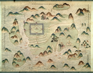
Fold-out coloured copy, 13 pieces in total. It depicts the 14 counties of Canton Fu (now Guangzhou) during the Qing Dynasty in traditional Chinse painting style. Macao Peninsula is included in the description of Xiangshan, illustrated with three buildings, namely the Border Gate and Church of Mater Dei from north to south, while the third in the Southwest corner of Macao Peninsula is labelled ‘Macao’.
|
|
Note:
|
City Plans of Macao
|
|
Note:
|
Images of Macao
|
|
Subject:
|
Aerial views
|
|
Subject:
|
Administrative and political divisions
|
|
Geographic Area:
|
Guangzhou Shi (China)
|
|
Geographic Area:
|
Zhongshan Shi (China)
|
|
Geographic Area:
|
Zhuhai Shi (China)
|
|
Geographic Area:
|
Macao (China)
|
|
Pub Title:
|
廣州府分縣圖
|
|
Pub Author:
|
Anonymous
|
|
Pub Year:
|
[1821-1911]
|
|
Provenance:
|
Peking University Library
|
|
MUST holding:
|
http://10.20.100.239/record=b1390012
|