Detail View: Old Maps Collection: Platte Grondt van Stadt Macao, waer in aen geweesen wordt de voornaemste Plaetsen der Stadt
|
Barcode:
|
4687820500716
|
|
Title:
|
Platte Grondt van Stadt Macao, waer in aen geweesen wordt de voornaemste Plaetsen der Stadt
|
|
Other Title:
|
Great Plan of the city of Macao, where the main sites of the city are indicated
|
|
Other Title:
|
Plattegrond van Stad Macao, water in een gewezen wordt de voornaemste Plaetsen der Stad
|
|
Other Title:
|
Plattegrondt van [de] stadt Macao
|
|
Contributor:
|
Vinckeboons, Joan, 1617-1670, cartographer
|
|
Category:
|
City Plans & Views
|
|
Type:
|
Manuscripts
|
|
Language:
|
Dutch
|
|
Create Year:
|
[ca. 1665]
|
|
Format:
|
JPEG, 7055 × 5000, 17MB
|
|
Scale:
|
Scale not given.
|
|
Physical Map Dimension (cm):
|
42 x 59 cm
|
|
Note:
|
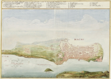
Although Joan Vinckeboons has never been to Asia himself he made quite a few city elevations, plans, coastal profiles and sea charts with combined information based on reports and sketches that masters, helmsmen and merchants made on their travels under the orders of the Dutch East India Company and Dutch West India Company. In this water colour, just as on the other of Macao by Vinckeboons, the aerial perspective is maintained but the representation of buildings is replaced by the geometry typical of a plan. Compared to the other view this particular one is elongated on the north to be able to show the Border Gate. On the legend, at the top of the plan, there are marked 26 places, both in land and on the Inner Harbour. The military interest of said legends is undeniable, take for instance n.o 1 'Is Het Principaele fort St Palilo [sic] Leyt hoogh 185 Trappen met 18 stucken geschat' states the exact location of the main São Paulo Fort and the number of artillery pieces present; n.o 8 'St Francisca waer op Syn 10 Stucken' states the São Francisco Fort with it's 10 artillery pieces and n.o 16 'De Baare heest 15 Stucken' the Barra Fort with 15.
|
|
Note:
|
Original is a manuscript map from the Manuscript Atlas of Joan Vinckeboons, 41 x 59 cm.
|
|
Note:
|
Oriented with East at the top.
|
|
Note:
|
Relief shown pictorially.
|
|
Note:
|
Outlined in yellow fillet.
|
|
Note:
|
City Plans of Macao.
|
|
Reference:
|
Oliveira, F.R. Cartografia antiga da cidade de Macau, c. 1600-1700: confronto entre modelos de representação europeus e chineses, Scripta Nova, vol. X. n.º 218 (53), 1 de agosto de 2006
|
|
Reference:
|
Silveira, L. Ensaio de Iconografia das Cidades Portuguesas do Ultramar, pl. 847
|
|
Subject:
|
Aerial views
|
|
Geographic Area:
|
Macao (China)
|
|
Pub Title:
|
Atlas Vingboons
|
|
Pub Author:
|
Vinckeboons, Joan, 1617-1670
|
|
Pub Year:
|
[ca. 1665]
|
|
Pub location:
|
[S.l.]
|
|
Provenance:
|
National Archives of the Netherlands
|
|
Provenance:
|
https://www.nationaalarchief.nl/en/research/map-collection/af87d266-d0b4-102d-bcf8-003048976d84
|
|
Provenance Call No.:
|
4.VELH619-65.
|
|
MUST holding:
|
https://must.primo.exlibrisgroup.com/permalink/853MUST_INST/reglfj/alma991002941649805076
|