Detail View: Old Maps Collection: A map of the city and harbour of Macao
|
Barcode:
|
4687820500710
|
|
Title:
|
A map of the city and harbour of Macao
|
|
Other Title:
|
Fort Guia
|
|
Other Title:
|
Fort Barra
|
|
Other Title:
|
Fort Monte
|
|
Other Title:
|
Fort Bomparto
|
|
Other Title:
|
Fort S.t Francisco
|
|
Other Title:
|
Typa Anchorage
|
|
Other Title:
|
Praya Grande
|
|
Contributor:
|
Bramston, William, 17---18--, author
|
|
Category:
|
Sea Charts
|
|
Type:
|
Printed
|
|
Language:
|
English
|
|
Create Year:
|
1840
|
|
Format:
|
JPEG, 1788 × 2500, 2.1MB
|
|
Scale:
|
Scale indeterminable.
|
|
Physical Map Dimension (cm):
|
50 x 36 cm
|
|
Note:
|
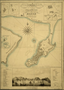
This is a plan of the city of Macau with buildings being represented geometrically. The whole map was produced from an aerial perspective, depicting streets and mountain peaks in the city of Macao. On the bottom part the legend identifies 58 important places and the map describes the prosperity of Macau. From the left to the right on the top part of the map there are 5 insets of the floor plans of Guia Fortress, São Tiago da Barra Fortress, Mount Fortress, Fortress of Our Lady of Bom Parto and San Francisco Fortress. Inset 6 is in aid for anchorage on the Typa Island so some soundings are given for Macao Inner Harbor, Small and Big Typa and Coloane.
|
|
Note:
|
Inset 1: Fort Guia. - Scale not given. - 6 x 5 cm. -- Inset 2: Fort Barra. - Scale not given. - 6 x 6 cm. -- Inset 3: Fort Monte. - Scale indeterminable. - 7 x 10 cm. -- Inset 4: Fort Bomparto. - Scale not given. - 3 x 5 cm. -- Inset 5: Fort S.t Francisco. - Scale not given. - 4 x 5 cm. -- Inset 6: Typa Anchorage. - Scale indeterminable. - 7 x 5 cm. -- Inset 7: Praya Grande. - Scale not given. - 10 x 22 cm.
|
|
Note:
|
Original is a four sheet lithograph mounted on cloth.
|
|
Note:
|
On the left bottom of the map: "J. Wyld, Charing Cross East lithog." and on the right bottom corner: "Entered at Stationers Hall."
|
|
Note:
|
There is an 16-point compass rose with a fleur de lis indicating north with dash dotted rhumb lines for the half-winds. The inset of Praia Grande is a view of Macao seen from the sea. The view depicts a busy inner harbour of Macao with a vast number of vessels both western and Chinese, which asserts the city as an important trade center. There forts built in strategic locations are identified on the bottom part. All forts are hoisting a Portuguese flag.On Heang Shan there is a small depiction of the Casa Branca.
|
|
Note:
|
Title in scroll work cartouche.
|
|
Note:
|
There are three scale lines on the map. Two scale lines in miles for the map and inset 6, and one in feet for inset 3.
|
|
Note:
|
Relief shown by hachures. And on inset 6 bathymetric relief is shown by soundings.
|
|
Note:
|
Map outlined in triple fillet and insets in double fillet.
|
|
Note:
|
City plans of Macao.
|
|
Note:
|
Macao and its surroundings.
|
|
Reference:
|
Hong Kong Museum of Art = 香港藝術館. The Chater Legacy : A selection of the Chater Collection = 香江遺珍 : 遮打爵士藏品選, p. 87
|
|
Reference:
|
Braga, S. Making Impressions: the adaptation of a Portuguese family to Hong Kong, 1700-1950, p. 27
|
|
Geographic Area:
|
Macao (China)
|
|
Provenance:
|
The National Archives (United Kingdom)
|
|
Provenance:
|
http://discovery.nationalarchives.gov.uk/details/r/C3820628
|
|
Provenance Call No.:
|
FO 925/4272
|
|
MUST holding:
|
https://must-primo.exlibris.com.cn/permalink/853MUST_INST/171sgkf/alma991000059109705076
|