Detail View: Old Maps Collection: 萬里海防圖說 = Illustrated map of Qing Empire coastal fortifications. Part 4
|
Barcode:
|
4687820500705
|
|
Title:
|
萬里海防圖說 = Illustrated map of Qing Empire coastal fortifications. Part 4
|
|
Original Title:
|
萬里海防圖說 = Illustrated map of Qing Empire coastal fortifications. Part 4
|
|
Contributor:
|
Tan, Jiuchou, active 17th century
|
|
Contributor:
|
Zhang, Qianyi, jin shi 1712
|
|
Contributor:
|
Hummel, Arthur W. (Arthur William), 1884-1975
|
|
Category:
|
Thematic Maps
|
|
Type:
|
Manuscripts
|
|
Language:
|
Chinese
|
|
Create Year:
|
1725
|
|
Format:
|
JPEG2000, 28280 × 4019, 17.7MB
|
|
Scale:
|
Scale not given
|
|
Physical Map Dimension (cm):
|
32 × 1600
|
|
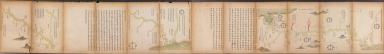
Note:
|
2 ms. maps on 1 sheet, title: 万里海防圖, 膠莱河辨议图说汇辑. Shows defense installations of the Grand Canal and the Chinese coast line from Hainan Island to Liaodong Peninsula. Originally drawn during Ming Jiaqing period between1524 and 1526. The map was a copy drawn in 1725. Oriented with north to the left. Includes text.
|
|
Subject:
|
Coast defenses
|
|
Geographic Area:
|
Grand Canal (China)
|
|
Relation Note:
|
Part 1 : 4687820500702, Part 2 : 4687820500703, Part 3 : 4687820500704, Part 5 : 4687820500706, Part 6 : 4687820500707, Part 7 : 46878205007078
|
|
Pub Title:
|
萬里海防圖說
|
|
Pub Author:
|
Tan, Jiuchou, active 17th century
|
|
Pub Author:
|
Zhang, Qianyi, jin shi 1712
|
|
Pub Author:
|
Hummel, Arthur W. (Arthur William), 1884-1975
|
|
Pub Year:
|
[1725]
|
|
Provenance:
|
Library of Congress Map Collections
|