Detail View: Old Maps Collection: 京版天文全圖 = Complete map of astronomy and the Qing Empire
|
Barcode:
|
4687820500677
|
|
Title:
|
京版天文全圖 = Complete map of astronomy and the Qing Empire
|
|
Original Title:
|
京版天文全圖 = Complete map of astronomy and the Qing Empire
|
|
Contributor:
|
馬俊良, active 18th century-19th century
|
|
Contributor:
|
黄宗羲, 1610-1695
|
|
Category:
|
General Maps
|
|
Type:
|
Printed
|
|
Language:
|
Chinese
|
|
Create Year:
|
1790
|
|
Format:
|
JPEG2000, 8980 × 16687, 29.1MB
|
|
Scale:
|
Scale not given
|
|
Physical Map Dimension (cm):
|
142 × 73
|
|
Note:
|
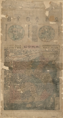
Shows two hemispheres, the territory, administrative divisions, and topographical features of the Qing Empire. Based on map of China drawn by Huang Lizhou in 1673. Includes text, lists of provinces, and maps of 2 hemispheres. 3 maps on 1 sheet, contents: 海國聞見錄四海總圖 -- 內板山海天文全圖 -- 輿地全圖.
|
|
Geographic Area:
|
China
|
|
Geographic Area:
|
World
|
|
Pub Title:
|
京版天文全圖
|
|
Pub Author:
|
馬俊良, active 18th century-19th century
|
|
Pub Author:
|
黄宗羲, 1610-1695
|
|
Pub Year:
|
[after 1790]
|
|
Pub location:
|
[China]
|
|
Provenance:
|
Library of Congress Map Collections
|