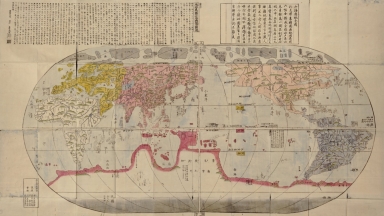
Detail View: Old Maps Collection: 山海輿地全圖 = Sankai yochi zenzu

|
Barcode:
|
4687820500672
|
|
Title:
|
山海輿地全圖 = Sankai yochi zenzu
|
|
Original Title:
|
山海輿地全圖 = Sankai yochi zenzu
|
|
Contributor:
|
Nagakubo, Sekisui, 1717-1801
|
|
Contributor:
|
Ricci, Matteo, 1552-1610
|
|
Category:
|
General Maps
|
|
Type:
|
Printed
|
|
Language:
|
Japanese
|
|
Create Year:
|
1785
|
|
Format:
|
JPEG2000, 19206 × 10821, 31.4MB
|
|
Scale:
|
ca. 1:27,000,000 at the equator
|
|
Physical Map Dimension (cm):
|
70 × 148
|
|
Note:
|
Shows continents and oceans of the world at about 1600. Based on Matteo Ricci's World map which was published in China in 1602. Includes text. At head of text: Chikyū bankoku sankai yochi zenzu setsu (地球萬國山海輿地全圖說)
|
|
Note:
|
Macao in World Maps
|
|
Geographic Area:
|
World
|
|
Pub Title:
|
山海輿地全圖
|
|
Pub Author:
|
Nagakubo, Sekisui, 1717-1801
|
|
Pub Year:
|
[1785?]
|
|
Pub location:
|
Naniwa, Akitaya Taemon
|
|
Provenance:
|
Library of Congress Map Collections
|