Detail View: Old Maps Collection: 三才一貫圖 = Map of the three powers unified
|
Barcode:
|
4687820500671
|
|
Title:
|
三才一貫圖 = Map of the three powers unified
|
|
Original Title:
|
三才一貫圖 = Map of the three powers unified
|
|
Contributor:
|
呂撫, active 1722-1732
|
|
Category:
|
General Maps
|
|
Type:
|
Printed
|
|
Language:
|
Chinese
|
|
Create Year:
|
1722
|
|
Format:
|
JPEG2000, 10469 × 18104, 38.3MB
|
|
Scale:
|
Scale not given
|
|
Physical Map Dimension (cm):
|
155 × 89
|
|
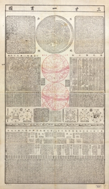
Note:
|
Primary coverage includes maps of China and the world, and astronomical map of the polar regions (northern and southern hemispheres). Includes chronological table of Chinese history (the dynasties), charts of the 8 phenomena, maps of the planets and their orbits, excerpts of Chinese classic literature (Daxue), etc., and other writings. Contents: Da Qing wan nian yi tong tian xia quan tu -- Tian di quan tu -- Nan bei liang ji xing tu.
|
|
Subject:
|
Astronomy
|
|
Subject:
|
Charts, diagrams, etc.
|
|
Geographic Area:
|
China
|
|
Geographic Area:
|
World
|
|
Pub Title:
|
三才一貫圖 = Map of the three powers unified
|
|
Pub Author:
|
Lü, Fu, active 1722-1732
|
|
Pub Year:
|
[1722]
|
|
Pub location:
|
Shaoxing [China]
|
|
Provenance:
|
Library of Congress Map Collections
|