Detail View: Old Maps Collection: 輿地全圖 = Complete map of imperial territory
|
Barcode:
|
4687820500669
|
|
Title:
|
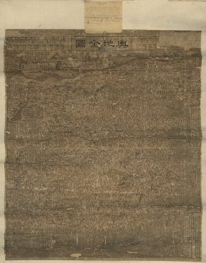
輿地全圖 = Complete map of imperial territory
|
|
Original Title:
|
輿地全圖 = Complete map of imperial territory
|
|
Contributor:
|
Hummel, Arthur W. (Arthur William), 1884-1975
|
|
Category:
|
General Maps
|
|
Type:
|
Manuscripts
|
|
Language:
|
Chinese
|
|
Create Year:
|
1798
|
|
Format:
|
JPEG2000, 8609 × 10991, 22.1MB
|
|
Scale:
|
ca. 1:4,000,000
|
|
Physical Map Dimension (cm):
|
80 × 68
|
|
Note:
|
Covers an area from Tula River in the north to the Great Wall and Wanlishitang Islands in the South China Sea, and from Korea in the east to the Pamirs in the west.
|
|
Note:
|
Macao in China Maps
|
|
Geographic Area:
|
China
|
|
Pub Title:
|
輿地全圖 = Complete map of imperial territory
|
|
Pub Author:
|
Hummel, Arthur W. (Arthur William), 1884-1975
|
|
Pub Year:
|
1798-1800
|
|
Pub location:
|
[China]
|
|
Provenance:
|
Library of Congress Map Collections
|