Detail View: Old Maps Collection: 大清萬年一統天下全圖 = The great Qing Dynasty's complete map of all under heaven
|
Barcode:
|
4687820500668
|
|
Title:
|
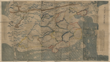
大清萬年一統天下全圖 = The great Qing Dynasty's complete map of all under heaven
|
|
Original Title:
|
大清萬年一統天下全圖 = The great Qing Dynasty's complete map of all under heaven
|
|
Contributor:
|
黃千人, active 18th century
|
|
Category:
|
General Maps
|
|
Type:
|
Printed
|
|
Language:
|
Chinese
|
|
Create Year:
|
1811
|
|
Format:
|
JPEG2000, 28695 × 16274, 95.9MB
|
|
Page No.:
|
1
|
|
Scale:
|
ca. 1:2,500,000
|
|
Physical Map Dimension (cm):
|
132 × 239
|
|
Note:
|
Covers from Korea to India, from Russia to Brunei. Shows the world known to the Chinese, with China at the center of the map. Based on the original map drawn by Huang Qianren in 1767.Includes text.
|
|
Subject:
|
Early maps
|
|
Subject:
|
World -- Maps
|
|
Subject:
|
Earth
|
|
Geographic Area:
|
China
|
|
Geographic Area:
|
World
|
|
Pub Title:
|
大清萬年一統天下全圖 = The great Qing Dynasty's complete map of all under heaven
|
|
Pub Author:
|
黃千人, active 18th century
|
|
Pub Year:
|
1811
|
|
Pub location:
|
[China]
|
|
Provenance:
|
Library of Congress Map Collections
|
|
MUST holding:
|
http://10.20.100.239/record=b1390054
|