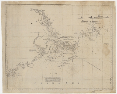
Detail View: Old Maps Collection: [Chart of the China Sea]
|
Barcode:
|
4687820500041
|
|
Title:
|
[Chart of the China Sea]
|
|
Original Title:
|
N/A
|
|
Contributor:
|
Norie, J. W. (John William), 1772-1843
|
|
Category:
|
Sea Charts
|
|
Type:
|
Printed
|
|
Language:
|
English
|
|
Create Year:
|
1840
|
|
Format:
|
JPEG, 19943 × 16078, 83MB
|
|
Page No.:
|
1
|
|
Scale:
|
Scale not given
|
|
Physical Map Dimension (cm):
|
63 × 79
|
|
Note:
|
Title supplied by cataloger. Map traced off a printed map published: London : by J.W. Norie, April 13th 1840. Includes land profiles and sailing directions.
|
|
Note:
|
Macao and the surrounding islands were depicted in this map.
|
|
Note:
|
局部圖
|
|
Note:
|
Macao and its Surroundings
|
|
Note:
|
Macao in Routes
|
|
Subject:
|
Nautical charts
|
|
Geographic Area:
|
Macao (China)
|
|
Geographic Area:
|
Pearl River Delta (China)
|
|
Pub Title:
|
[Chart of the China Sea]
|
|
Pub Author:
|
Norie, J. W. (John William), 1772-1843
|
|
Pub Year:
|
1840
|
|
Pub location:
|
London
|
|
Provenance:
|
Harvard Map Collection - Harvard College Library
|
|
MUST holding:
|
http://10.20.100.239/record=b1407560
|