Detail View: Old Maps Collection: 澳門市全圖 = City plan of Macau
|
Barcode:
|
4687820500660
|
|
Title:
|
澳門市全圖 = City plan of Macau
|
|
Original Title:
|
澳門市全圖 = City plan of Macau
|
|
Contributor:
|
Anonymous
|
|
Category:
|
City Plans & Views
|
|
Type:
|
Printed
|
|
Language:
|
Chinese
|
|
Create Year:
|
1953?
|
|
Format:
|
JPEG2000, 4270 × 5241, 3.4MB
|
|
Scale:
|
[ca. 1:10,000]
|
|
Physical Map Dimension (cm):
|
41 × 34
|
|
Note:
|
Duplicate of Macau city plan in 1952-53 "Commercial and Industrial Yearbook".
|
|
Note:
|
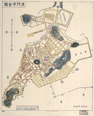
The map described some new building and major urban planning, including the Reservervatorio de Agua in the northeast, Air Harbor Seaplane on the Porto Exterior and the Zona de Aterros do Porto Exterior Which was the large land reclamation of macao on 50's.In addition to,Goverment was constructed some new squatters in Nossa Senhora de Fátima which is the northernmost and largest freguesia in Macau Peninsula, including Ilha Verde Squatter and Squatter of Barbosa.
|
|
Note:
|
City Plans of Macao
|
|
Subject:
|
Regional planning
|
|
Geographic Area:
|
Macao (China)
|
|
Pub Title:
|
澳門市全圖
|
|
Pub Author:
|
Anonymous
|
|
Pub Year:
|
1953?
|
|
Pub location:
|
Macau
|
|
Provenance:
|
Library of Congress Map Collections
|
|
MUST holding:
|
http://10.20.100.239/record=b1346861
|