Detail View: Old Maps Collection: Macau (Macao) Special Administrative Region
|
Barcode:
|
4687820500659
|
|
Title:
|
Macau (Macao) Special Administrative Region
|
|
Other Title:
|
Map of China
|
|
Contributor:
|
United States. Central Intelligence Agency, author, publisher
|
|
Category:
|
General Maps
|
|
Type:
|
Printed
|
|
Language:
|
English
|
|
Language:
|
Portuguese
|
|
Create Year:
|
2008
|
|
Format:
|
JPEG 2000, 2166 × 2973, 588KB
|
|
Scale:
|
Scale 1:11,000,000 ; Transverse Mercator proj. (E 113⁰32ʹ--E 113⁰36ʹ/N 22⁰12ʹ--N 22⁰08ʹ)
|
|
Physical Map Dimension (cm):
|
21 x 17 cm, on sheet 25 x 19 cm
|
|
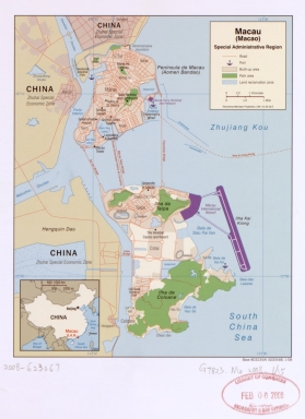
Note:
|
Map of Macao, Taipa, Cotai and Coloane with all the roads, ports, bays, the built-in and park areas and land reclamation zones. There are also marked other areas of touristic interest. The inset on the left bottom corner is a map of China with the location of Beijing, Macau S.A.R. and Taiwan.
|
|
Note:
|
Inset 1: Map of China. - 4 x 5 cm.
|
|
Note:
|
Original is a colored printed map, 21 x 17 cm.
|
|
Note:
|
On the left and upper part of the map it can be seen Zhuhai Special Economic Zone and the roads that connect it to Macao and Cotai.
|
|
Note:
|
Scale line of the main map at the bottom of the legend in kilometers and miles. Inset with scale line at the top.
|
|
Note:
|
Main map with graticule.
|
|
Note:
|
Map and inset outlined in simple fillet.
|
|
Note:
|
Relief shown by shading.
|
|
Note:
|
Macao and its surroundings.
|
|
Geographic Area:
|
Macao (China)
|
|
Provenance:
|
Library of Congress
|
|
Provenance:
|
https://lccn.loc.gov/2008623067
|
|
Provenance Call No.:
|
G7823.M2 2008 .U5
|
|
MUST holding:
|
https://must.primo.exlibrisgroup.com/permalink/853MUST_INST/171sgkf/alma991002943549805076
|