Detail View: Old Maps Collection: Charta Rogeriana
|
Barcode:
|
3687800354590F
|
|
Title:
|
Charta Rogeriana
|
|
Original Title:
|
Weltkarte des Idrisi vom Jahr 1154 n. Ch., Charta Rogeriana
|
|
Original Title:
|
نزهة المشتاق في اختراق الآفاق
|
|
Other Title:
|
Tabula Rogeriana
|
|
Contributor:
|
Idrīsī, ca. 1100-1166, cartographer
|
|
Contributor:
|
Miller, Konrad, 1844-1933, editor, publisher
|
|
Category:
|
Early Old Maps
|
|
Type:
|
Manuscripts
|
|
Language:
|
Arabic
|
|
Create Year:
|
1928
|
|
Create Year:
|
1154
|
|
Format:
|
JPEG 2000, 23617 × 10780, 38.5MB
|
|
Scale:
|
Scale not given.
|
|
Physical Map Dimension (cm):
|
99 x 98 cm, on sheet 122 x 111 cm
|
|
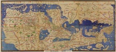
Note:
|
Abu 'Abdallah Muhammad ibn Muhammad al-Sharif al-Idrisi, was born in Sabta, Ceuta, and educated in Cordoba. He travelled widely in North Africa, Europe and Anatolia. In about 1138 the Norman king of Sicily, Roger II, invited al-Idrisi to his court in Palermo, and commissioned him to compile a description of the entire contemporary world. In collaboration al-Idrisi produced a large circular world map engraved on silver, a map now lost, and a book, which was to provide the supplementary text. Most often known as Tabula Rogeriana (Nuzhat al-mushtāq) it is a description of the world written in Arabic and accompanied by seventy regional maps and one world map, the book divided the world into seven climates, in keeping with the Ptolemaic system. Each region was thoroughly described in its physical, political, economic and cultural conditions. The book proved to be a great success in the Arabic world, and was copied and translated for centuries. In the western world, it was first printed in Rome in Arabic characters in 1592, then partially translated and published in Latin in 1619. The book served as major tool for Italian, Dutch and French mapmakers from the only ten manuscript copies of the book survive, dating from the early 1300's to the late 1500's; five of which have complete text and eight have maps. The most complete manuscript, which includes the world map and all seventy sectional maps, is kept in Istanbul. The map shows the world from Spain to Korea. A large continent stretches out from eastern Africa, land locking the Indian Ocean except for the eastern side. The map is divided into seven horizontal climate zones, and further split into ten vertical divisions. The place-names are at their densest around the coasts but they appear to refer to settlements only, not to natural features, though a few rivers and mountain ranges are identified. However, both the purpose of the map and the way its information was gathered were fundamentally different to those of the portolan chart. The density of the inland detail confirms that al-Idrīsī was focused more on topography than hydrography and certainly not on the needs of sailors. The map reflects a landsman’s view.
|
|
Note:
|
This is a facsimile of an original separated into 70 rectangular sections dispersed unevenly throughout the volume’s 350 folios, 85 x 193 cm.
|
|
Note:
|
The sea is represented in wavy blue lines.
|
|
Note:
|
Map oriented with South at the top.
|
|
Note:
|
Relief shown pictorially.
|
|
Note:
|
Map outlined in gold border.
|
|
Reference:
|
Parry, J.V. Mapping Arabia, pp 20-37
|
|
Reference:
|
Campbell, T. The Charta Rogeriana:a reappraisal of the making of al-Idrīsī's world map of 1154 and its dissemination, https://www.maphistory.info/ChartaRogeriana.html
|
|
Subject:
|
Early maps
|
|
Geographic Area:
|
World
|
|
Geographic Area:
|
Europe
|
|
Geographic Area:
|
Asia
|
|
Geographic Area:
|
Africa
|
|
Provenance:
|
Library of Congress
|
|
Provenance:
|
https://lccn.loc.gov/2007626789
|
|
Provenance Call No.:
|
G3200 1154 .I3 1928 Vault Oversize
|
|
MUST holding:
|
https://must.primo.exlibrisgroup.com/permalink/853MUST_INST/171sgkf/alma991003020349505076
|