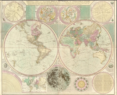
Detail View: Old Maps Collection: Bowles's new and accurate map of the world, or Terrestrial globe : laid down from the best observations and newest discoveries particularly those lately made in the south seas by Anson, Byron, Wallis, Bouganville, Cook, and other celebrated circumnavigators, illustrated with a variety of useful projections and representations of the heavenly bodies the most approved astronomical and geographical definitions tables, and problems with an easy and familiar explanation of the most curious and interesting phoenomena in the universal system
|
Barcode:
|
4687820500654
|
|
Title:
|
Bowles's new and accurate map of the world, or Terrestrial globe : laid down from the best observations and newest discoveries particularly those lately made in the south seas by Anson, Byron, Wallis, Bouganville, Cook, and other celebrated circumnavigators, illustrated with a variety of useful projections and representations of the heavenly bodies the most approved astronomical and geographical definitions tables, and problems with an easy and familiar explanation of the most curious and interesting phoenomena in the universal system
|
|
Original Title:
|
Bowles's new and accurate map of the world, or Terrestrial globe : laid down from the best observations and newest discoveries particularly those lately made in the south seas by Anson, Byron, Wallis, Bouganville, Cook, and other celebrated circumnavigators, illustrated with a variety of useful projections and representations of the heavenly bodies the most approved astronomical and geographical definitions tables, and problems with an easy and familiar explanation of the most curious and interesting phoenomena in the universal system
|
|
Contributor:
|
Bowles, Carington, 1724-1793
|
|
Category:
|
Hemispheres
|
|
Type:
|
Printed
|
|
Language:
|
English
|
|
Create Year:
|
1780
|
|
Format:
|
JPEG2000, 15427 × 12641, 29.5MB
|
|
Scale:
|
Scale not given
|
|
Physical Map Dimension (cm):
|
106 × 130
|
|
Note:
|
Ancillary maps: Solar system -- Northern hemisphere -- Southern hemisphere -- Astronomical latitude and longitude analemma -- Universal scale of equal parts, chords, sines, tangents, secants, & c. & c. -- Chart of the world according to Mercator's projection -- Selenography or a map of the moon -- Vicissitude of seasons explained -- Analemma.
|
|
Note:
|
Macao was marked on coast of Pearl River Estuary in this map.
|
|
Note:
|
Macao in World Maps
|
|
Subject:
|
Voyages around the world
|
|
Geographic Area:
|
World
|
|
Pub Year:
|
[1780?]
|
|
Pub location:
|
London
|
|
Provenance:
|
Library of Congress Map Collections
|