Detail View: Old Maps Collection: [Cantino world map]
|
Barcode:
|
4687820500651
|
|
Title:
|
[Cantino world map]
|
|
Other Title:
|
[Cantino planisphere]
|
|
Other Title:
|
[La Carta del Cantino]
|
|
Other Title:
|
[Carta da navigar per le isole novam[en]te tr[ovate] in le parte de l'India]
|
|
Contributor:
|
Cantino, Alberto, fl. 1502, creator
|
|
Category:
|
Sea Charts
|
|
Type:
|
Manuscripts
|
|
Language:
|
Latin
|
|
Language:
|
Portuguese
|
|
Language:
|
Spanish
|
|
Create Year:
|
1502
|
|
Format:
|
JPEG, 10605 × 5000, 41.8MB
|
|
Scale:
|
[ca. 1:12,820,000]
|
|
Physical Map Dimension (cm):
|
105 x 224 cm, on sheet 113 x 228 cm
|
|
Note:
|
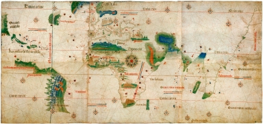
This map is the earliest surviving map showing Portuguese geographic discoveries in the East and West. It is named after Alberto Cantino, an undercover agent for Ercole D'Este the Duke of Ferrara. Cantino staying in Lisbon bribed an unknown Portuguese cartographer to make a standardize world map which was send to his master in Italy in November 1502. For 90 years the map was kept in the ducal library until the Pope Clement VIII moved it to another palace in Modena. It remained there until the 1859 riots when it was lost until a staff member of the Biblioteca Estense found it hanging as a drape in a butcher's shop. The Library bought the map in 1868 and showed it to the world. The map is particularly notable for portraying a fragmentary record of the Brazilian coast, which the Portuguese explorer Pedro Álvares Cabral explored in 1500, and for depicting the African coast of the Atlantic and Indian Oceans with a remarkable accuracy and detail. As a matter of fact a piece of parchment was pasted on the north and north-eastern coast of Brazil to correct the coast line, a revision made in a hurry in the desire to add the knowledge brought the expedition of 1501-2. It was valuable at the beginning of the sixteenth century because it showed detailed and up-to-date strategic information in a time when geographic knowledge of the world was growing at a fast pace. Actually some of the latest information on the discoveries received in Lisbon at the time -even if far from accurate- have their first cartographic representation in this map. The Cantino planisphere is the earliest extant nautical chart where places (in Africa and parts of Brazil and India) are depicted according to their astronomically observed latitudes.
|
|
Note:
|
The original map belongs to Biblioteca Estense Universitaria, Modena, Italy, and is in six parchment sheets glued together side by side on canvas, 105 x 220 cm. It has an inscription on the back on the bottom left corner 'Carta da navigar per le isole novam.te tr[ovate] in le parte de l'India: dono Alberto Cantino al S. Duca Hercole'.
|
|
Note:
|
The lines for the Tropic of Cancer, Capricorn and the Arctic Circle are in red and named in Latin. The Equator line is gold and also named in Latin. The Papal meridian from the Treaty of Tordesillas is blue and named in Portuguese as 'Este he o marco dantre Castella [et] Portugall'.
|
|
Note:
|
The Tropics, the Equator, the Arctic Circle, the Poles and the Oceans are written in Latin but all the place names and the notes are written in old Portuguese with some lapses into Spanish, particularly in Spain, and Castilian America. The numerous and more or less extensive inscriptions have information about the discoveries and their partakers, about the kings of some of the lands, which goods each territory had for trade and even notes about missions.
|
|
Note:
|
The map has a big center 32-point compass rose very ornamented in red, blue, green, gold and black, with a face at the middle and a fleur-de-lis indicating north. There are 21 smaller 8-point compass roses in red, gold and blue. As for the rhumb lines, the principal winds are in gold, the half winds in green and the quarter winds in red.
|
|
Note:
|
The is illustrated with birds and plants particularly in Brazil and Africa in which we can also see natives and native huts. There are three castles or palaces -one in Europe representing Venice; other in Africa depicting Castelo de São Jorge da Mina, today named Elmina Castle; and the last in Middle East depicting Jerusalem. The Tower of Babel is drawn horizontally in Egypt. Across the map there are heraldic devices and flags of the nations the lands belonged to. In Africa and Brazil there are many Portugueses flags, in Europe English and Spanish flags and in Middle East many Turkey flags. Along the central African coast are depicted the cross stone markers erected by Diogo Cão and Bartolomeu Dias.
|
|
Note:
|
The usage of blue for water masses was reserved for the Mediterranean, the Baltic, and unbounded Caspian sea. The Red Sea was colored red.
|
|
Note:
|
Relief even though scarce is shown pictorially. In the African continent is the Sierra Leone drawn as a lion-head, the mythical Mountains of the Moon -a legendary mountain or mountain range in east Africa at the source of the Nile River- and the Cape of Good Hope named 'Prasso Promo[n]torio'.
|
|
Note:
|
There are six tables of leagues on the map all of them in red and blue.
|
|
Note:
|
The place names are written in gold and red, usually the red ones being the more important.
|
|
Note:
|
The present outline of the map is a golden fillet which has been obviously cut, stating that the original map was larger on the four sides. There is a 'tail' from a letter showing on the upper left side of the map hinting that the bordure above might have had some information about the map, maybe a title, a date, name of the cartographer or simply acknowledging the patron.
|
|
Note:
|
Early old map depicting the world.
|
|
Reference:
|
Cortesão, A. Portugaliae Monumenta Cartographica, vol. 1, p. 7-13
|
|
Reference:
|
駛向東方 : 全球地圖中的澳門, 2014 年紀念冊 = Sailing to the East : Global Mapping of Macao, 2014 Yearbook, p. 16-19
|
|
Reference:
|
Crone, G.R. Maps and their Makers, p. 86-88
|
|
Reference:
|
Piersantelli, G. La pittura nella 'charta del navicare' del Cantino, Bollettino Civico Istituto Colombiano, anno I, no. 2, p. 38-50
|
|
Reference:
|
Roukema, E. Brazil in the Cantino Map, Imago Mundi, vol. 17, p. 7–26
|
|
Reference:
|
Pereira, M.S. O Novo Mundo no Planisfério da Casa de Este, o “Cantino”, Revista da Universidade de Coimbra, vol. 35, ano 1989, p. 271-308
|
|
Reference:
|
Metcalf, A.C. Who Cares Who Made the Map? La Carta del Cantino and its anonymous maker, e-Perimetron, vol. 12, no. 1, p. 1-23
|
|
Reference:
|
龔纓晏. 意大利間諜的戰利品: 《坎蒂諾地圖》, 地圖, 03期
|
|
Reference:
|
Cortesão, A. History of Portuguese cartography, vol. 1
|
|
Reference:
|
Cortesão, A. Cartigrafia e Cartógrafos Portugueses dos séculos XV e XVI
|
|
Reference:
|
Harrisse, H. Les Corte-Real et leurs voyages au Nouveau-monde
|
|
Reference:
|
Gaspar, J.F.F.A. From the Portolan Chart of the Mediterranean to the Latitude Chart of the Atlantic Cartometric Analysis and Modeling
|
|
Reference:
|
Leite, D. O mais antigo mapa do Brasil, História da Colonização Portuguesa do Brasil, vol. 2
|
|
Reference:
|
Torelló, J.C.O. A Spy, a Map, and the Quest for Power in 16th-Century Europe, Natinal Geographic Magazine, March/April 2017
|
|
Reference:
|
LOC https://lccn.loc.gov/2007626874
|
|
Geographic Area:
|
World
|
|
Provenance:
|
Bibliothèque et Archives Nationales du Québec
|
|
Provenance:
|
https://cap.banq.qc.ca/notice?id=p%3A%3Ausmarcdef_0003250629&locale=fr
|
|
Provenance Call No.:
|
G/3200/1502/C372/2004 CAR ro
|
|
MUST holding:
|
https://must.primo.exlibrisgroup.com/permalink/853MUST_INST/171sgkf/alma991000110619705076
|