Detail View: Old Maps Collection: Portolan chart of the Mediterranean
|
Barcode:
|
4687820500642
|
|
Title:
|
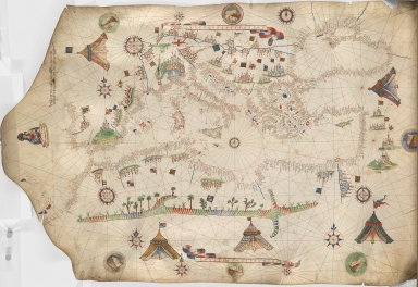
Portolan chart of the Mediterranean
|
|
Original Title:
|
Portolan chart of the Mediterranean
|
|
Contributor:
|
Maggiolo, Vesconte, active 1504-1549
|
|
Category:
|
Sea Charts
|
|
Type:
|
Manuscripts
|
|
Language:
|
Italian
|
|
Create Year:
|
1513
|
|
Format:
|
JPEG, 5000 × 6238, 14.8MB
|
|
Scale:
|
Scale not given
|
|
Physical Map Dimension (cm):
|
93 × 59.5
|
|
Note:
|
Autograph manuscript map (signed), in ink and watercolor on vellum, made in Naples. Title supplied by cataloger.
|
|
Note:
|
This is an early old map depicted the world
|
|
Subject:
|
Nautical charts
|
|
Subject:
|
Early maps
|
|
Geographic Area:
|
Mediterranean Sea
|
|
Pub Year:
|
1513
|
|
Provenance:
|
Harvard Map Collection - Harvard College Library
|