Detail View: Old Maps Collection: China Sea. Sheet 1.st to James Drummond Esquire in acknowledgement for his laudable endeavours towards perfecting the navigation of the China Sea
|
Barcode:
|
4687820500050
|
|
Title:
|
China Sea. Sheet 1.st to James Drummond Esquire in acknowledgement for his laudable endeavours towards perfecting the navigation of the China Sea
|
|
Contributor:
|
Horsburgh, James, 1762-1836, cartographer, publisher
|
|
Contributor:
|
James Drummond, 8th Viscount Strathallan, 1767-1851, dedicatee
|
|
Category:
|
Sea Charts
|
|
Type:
|
Printed
|
|
Language:
|
English
|
|
Create Year:
|
1811
|
|
Format:
|
JPEG 23166 × 15983, 93.5MB
|
|
Scale:
|
[ca. 1:2,200,000] (E 102°14ʹ00ʺ--E 120°53ʹ00ʺ/N 24°12ʹ00ʺ--N 12°32ʹ00ʺ)
|
|
Physical Map Dimension (cm):
|
55 x 84 cm, on sheet 73 x 119 cm
|
|
Note:
|
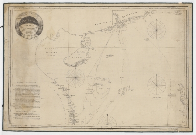
Captain James Horsburgh succeeded Alexander Dalrymple (1737-1808) as hydrographer of the English India Company (EIC) in 1795. This chart was the first reasonably accurate delineation of the Paracel Islands already known to seaman as 'The Dangerous Grounds' as it is stated in the legend on the left corner of the map. The Paracel Islands would not be fully surveyed until 1807 when Captain Daniel Ross was sent by the East India Company to the South China Sea. This knowledge is reflected in the second issue of this chart. The 'General Description' note gives an outline on how the chart was constructed, with the extensive use of chronometers to calculate longitude. It also states where the chart might be deficient. A lot of soundings are provided specially in coastal areas and the Macclesfield Bank is also heavily filled with depth measures. Some routes are identified with ship's name and date. Macao is marked with a small flag but wrongly written as 'Maeao'.
|
|
Note:
|
Original is a printed map, 58 x 88 cm.
|
|
Note:
|
Title inside a sphere surrounded by a circle drawing of a sea landscape. Two vessels, one on each side of the title, are headed towards and island with a Pagoda and a few houses, at the top, sided by another two islands. This pictorial cartouche seems to be a depiction of the Great Ladrone Islands and the Cape of Varela -also know as Cape Pagoda- due to its striking resemblance to that building. The Cape is situated at the lower left of the chart along the Vietnam coast, and was said to be visible from 60 nautical miles. The representation of a pagoda above the title, is most probably an allusion to the cape.
|
|
Note:
|
There are three and a half 32-point compass roses on the map with a fleur de lis indicating north.
|
|
Note:
|
Relief shown by hachures. Bathymetric relief given by soundings.
|
|
Note:
|
Map with graticule.
|
|
Note:
|
The four borders of the map with latitude and longitude lines.
|
|
Note:
|
Map outlined in simple bold fillet.
|
|
Note:
|
Macao and its surroundings.
|
|
Note:
|
Macao in routes.
|
|
Reference:
|
Hancox, D.J. A Geographical Description of the Spratly Islands and an Account of Hydrographic Surveys Amongst Those Islands, p. 32
|
|
Subject:
|
Nautical charts
|
|
Subject:
|
Coasts
|
|
Geographic Area:
|
China Sea
|
|
Geographic Area:
|
Vietnam
|
|
Geographic Area:
|
Paracel Islands
|
|
Geographic Area:
|
Hainan Sheng (China)
|
|
Provenance:
|
Harvard College Library
|
|
Provenance:
|
http://id.lib.harvard.edu/alma/990138089110203941/catalog
|
|
Provenance Call No.:
|
G9237.S6P5 1811 .H6
|
|
MUST holding:
|
https://must-primo.exlibris.com.cn/permalink/853MUST_INST/171sgkf/alma991000137449705076
|