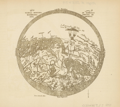
Detail View: Old Maps Collection: Tabula rotunda Rogeriana, 1154
|
Barcode:
|
4687820500639
|
|
Title:
|
Tabula rotunda Rogeriana, 1154
|
|
Original Title:
|
Tabula rotunda Rogeriana, 1154
|
|
Contributor:
|
Idrīsī, approximately 1100-1166
|
|
Category:
|
Hemispheres
|
|
Type:
|
Printed
|
|
Language:
|
English
|
|
Language:
|
Arabic
|
|
Create Year:
|
1893
|
|
Format:
|
JPEG, 6400 × 4920, 11.1MB
|
|
Scale:
|
Scale not given
|
|
Physical Map Dimension (cm):
|
20 × 26
|
|
Note:
|
Map drawn possibly in 1154 for King Roger II of Sicily. Facsimile of a manuscript map. Reproduced from Lelewel’s Atlas.
|
|
Note:
|
This is an early old map depicted the world
|
|
Subject:
|
Early maps
|
|
Geographic Area:
|
World
|
|
Relation Note:
|
From: The partition of Africa / J. Scott Keltie. London : E. Stanford, 1893.
|
|
Pub Title:
|
The partition of Africa
|
|
Pub Author:
|
Keltie, John Scott, Sir, 1840-1927
|
|
Pub Year:
|
1893
|
|
Pub location:
|
London
|
|
Provenance:
|
Harvard Map Collection - Harvard College Library
|