Detail View: Old Maps Collection: Typo de la carta cosmographica de Gaspar Vopellio medeburgense
|
Barcode:
|
4687820500629
|
|
Title:
|
Typo de la carta cosmographica de Gaspar Vopellio medeburgense
|
|
Original Title:
|
Typo de la carta cosmographica de Gaspar Vopellio medeburgense
|
|
Contributor:
|
Girava, Gerónimo, -1556
|
|
Contributor:
|
Vopel, Caspar, 1511-1561
|
|
Category:
|
Early Old Maps
|
|
Type:
|
Printed
|
|
Language:
|
Spanish
|
|
Create Year:
|
1556?
|
|
Format:
|
JPEG, 7210 × 5000, 17MB
|
|
Scale:
|
Scale not given
|
|
Physical Map Dimension (cm):
|
28 × 40
|
|
Note:
|
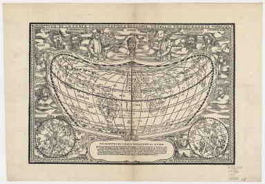
Cordiform woodcut world map showing an expanded North America. It depicts America and Asia as one landmass. Girava based this map on a 1545 wall map by Caspar Vopell who is acknowledged in the legend below the map. This map has the same cordiform projection used in Martin Waldseemuller's wall map of the world from 1507. Figures on the map are Gaius Julius Solinus to the left and Strabo to the right holding the tools of their trade. Also noted is Balboa's discovery of the Pacific Ocean.
|
|
Note:
|
This is an early old map depicted the world
|
|
Subject:
|
Early maps
|
|
Geographic Area:
|
World
|
|
Geographic Area:
|
Asia
|
|
Geographic Area:
|
North America
|
|
Pub Author:
|
Iuan Antonio Castellon, y maestro Christoual Caron
|
|
Pub Year:
|
1556
|
|
Pub location:
|
Milan
|
|
Provenance:
|
Harvard Map Collection - Harvard College Library
|