Detail View: Old Maps Collection: Portolan chart of the Mediterranean and Black Seas with the west coast of Spain and Portugal
|
Barcode:
|
4687820500624
|
|
Title:
|
Portolan chart of the Mediterranean and Black Seas with the west coast of Spain and Portugal
|
|
Original Title:
|
Portolan chart of the Mediterranean and Black Seas with the west coast of Spain and Portugal
|
|
Contributor:
|
Oliva, Placido, active 1575-1615
|
|
Category:
|
Sea Charts
|
|
Type:
|
Manuscripts
|
|
Language:
|
Italian
|
|
Create Year:
|
1575
|
|
Format:
|
JPEG2000, 12945 × 9596, 24.9MB
|
|
Scale:
|
Scale not given
|
|
Physical Map Dimension (cm):
|
74 × 51
|
|
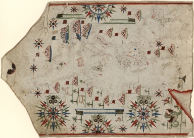
Note:
|
Portolan chart with seaport names given for all coastlines. Title devised by cataloguer. Fragmentary signature on upper right portion leading into neck reads "Io Placid...". Oriented with north to the right (indicated by fleurs-de-lys). Contains 10 small and 4 large compass roses centered on Sicily. Pen-and-ink and goauche, with traces of gilding. Includes 2 scale bars (unidentified units), fragment of an illustration on the neck, and many illustrations throughout.
|
|
Note:
|
This is an early old map depicted the world.
|
|
Subject:
|
Harbors
|
|
Subject:
|
Early maps
|
|
Geographic Area:
|
Mediterranean Sea
|
|
Pub Year:
|
158-?
|
|
Provenance:
|
Library of Congress Map Collections
|