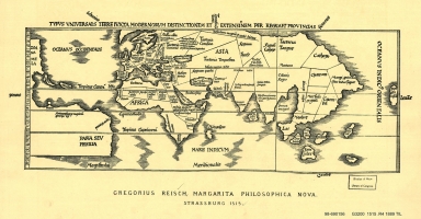
Detail View: Old Maps Collection: Typus universalis terre
|
Barcode:
|
4687820500618
|
|
Title:
|
Typus universalis terre
|
|
Original Title:
|
Typus universalis terre
|
|
Contributor:
|
Reisch, Gregor, -1525
|
|
Category:
|
General Maps
|
|
Type:
|
Printed
|
|
Language:
|
English
|
|
Create Year:
|
1889
|
|
Format:
|
JPEG2000, 5764 × 3008, 2.6MB
|
|
Scale:
|
Scale not given
|
|
Physical Map Dimension (cm):
|
35 × 51
|
|
Note:
|
From: A.E. Nordenskiold Facsimile atlas, 1889.
|
|
Note:
|
This is an early old map depicted the world.
|
|
Geographic Area:
|
World
|
|
Pub Title:
|
A.E. Nordenskiold Facsimile atlas
|
|
Pub Author:
|
Nordenskiöld, A. E. (Adolf Erik), 1832-1901
|
|
Pub Year:
|
1889
|
|
Provenance:
|
Library of Congress Map Collections
|